IMAGES TAKEN NEAR TO
East Street, BRIDGEND, CF32 9BH
Introduction
This page details the photographs taken nearby to East Street, CF32 9BH by members of the Geograph project.
The Geograph project started in 2005 with the aim of publishing, organising and preserving representative images for every square kilometre of Great Britain, Ireland and the Isle of Man.

There are currently over 7.5m images from over14,400 individuals and you can help contribute to the project by visiting https://www.geograph.org.uk
Image Map
Images are licensed for reuse under creativecommons.org/licenses/by-sa/2.0
Notes
- Clicking on the map will re-center to the selected point.
- The higher the marker number, the further away the image location is from the centre of the postcode.
Image Listing (202 Images Found)
Images are licensed for reuse under creativecommons.org/licenses/by-sa/2.0
Image
Details
Distance
1
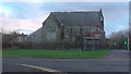
Aberkenfig Bridgend Road
Carey chapel Aberkenfig January 18th 2015 just few months before demolition.
Image: © Colin Prosser
Taken: 18 Jan 2015
0.01 miles
2
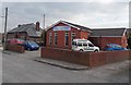
Church of God, Aberkenfig
Viewed across New Street. A banner on the building proclaims Happy 100th birthday 1912-2012.
The church dates its origins to March 10th 1912, when 7 people met for worship at a house in Maesteg Road, Tondu. It was known as the Church of God, Tondu in its early years.
The red brick church seen here was built in 1988.
Image: © Jaggery
Taken: 27 Mar 2013
0.01 miles
3

Church of God Aberkenfig
The current red brick church was built in 1988 on a site that was formerly a tin shack (used as the church) and a junk yard.
Image: © Steve Barnes
Taken: 16 Oct 2023
0.02 miles
4
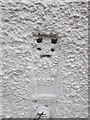
Ordnance Survey Flush Bracket (S1181)
This OS Flush Bracket can be found on the front of No41 Bridgend Road. It marks a point 47.640m above mean sea level.
Image: © Adrian Dust
Taken: 9 Mar 2016
0.03 miles
5
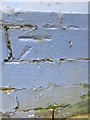
Ordnance Survey Cut Mark
This OS cut mark can be found on the front of Altered Images. No56 Bridgend Road. It marks a point 37.935m above mean sea level.
Image: © Adrian Dust
Taken: 9 Mar 2016
0.03 miles
6
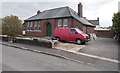
Former Aberkenfig Clinic, New Street, Aberkenfig
Renovation or conversion work is in progress at the former clinic at the eastern end of New Street.
Image: © Jaggery
Taken: 27 Mar 2013
0.03 miles
7
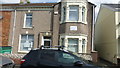
Doctor surgery
New Street Aberkenfig doctor surgery August 17th 2015
Image: © Colin Prosser
Taken: 17 Aug 2015
0.03 miles
8
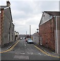
New Street, Aberkenfig
New Street is a 70 metre long residential cul-de-sac on the east side of Bridgend Road.
Image: © Jaggery
Taken: 27 Mar 2013
0.03 miles
9
Aberkenfig Conservative Club
Located at 8-10 Bridgend Road, Aberkenfig.
Image: © Jaggery
Taken: 27 Mar 2013
0.04 miles
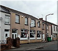
10
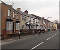
Bridgend Road houses between East Street and New Street, Aberkenfig
A view north from near the corner of East Street.
Aberkenfig Conservative Club http://www.geograph.org.uk/photo/3391573 is in the middle of the row.
Image: © Jaggery
Taken: 27 Mar 2013
0.04 miles