IMAGES TAKEN NEAR TO
Bridgend Road, BRIDGEND, CF32 9AE
Introduction
This page details the photographs taken nearby to Bridgend Road, CF32 9AE by members of the Geograph project.
The Geograph project started in 2005 with the aim of publishing, organising and preserving representative images for every square kilometre of Great Britain, Ireland and the Isle of Man.

There are currently over 7.5m images from over14,400 individuals and you can help contribute to the project by visiting https://www.geograph.org.uk
Image Map
Images are licensed for reuse under creativecommons.org/licenses/by-sa/2.0
Notes
- Clicking on the map will re-center to the selected point.
- The higher the marker number, the further away the image location is from the centre of the postcode.
Image Listing (173 Images Found)
Images are licensed for reuse under creativecommons.org/licenses/by-sa/2.0
Image
Details
Distance
1
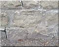
Ordnance Survey Cut Mark
This OS cut mark can be found on the wall west side of the road. It marks a point 47.717m above mean sea level.
Image: © Adrian Dust
Taken: 5 Sep 2021
0.03 miles
2
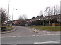
The road to Aberkenfig (South)
Viewed across the B4281. Most of Aberkenfig is on the north side of the B4281. This road heads into the southern part of the village. Though this is Bridgend Road, there is no longer a through route ahead for motor vehicles. The roadway is blocked off about 450 metres ahead. http://www.geograph.org.uk/photo/3395253
Image: © Jaggery
Taken: 27 Mar 2013
0.04 miles
3
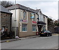
Swan Inn, Aberkenfig
Located at 128 Bridgend Road.
Image: © Jaggery
Taken: 27 Mar 2013
0.04 miles
4
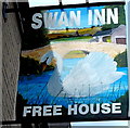
Swan Inn name sign, Aberkenfig
Attached to a wall here. http://www.geograph.org.uk/photo/3395647
Image: © Jaggery
Taken: 27 Mar 2013
0.04 miles
5
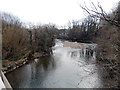
Ogmore River south of the B4281, Aberkenfig
The river flows away from the confluence http://www.geograph.org.uk/photo/3384683 of a stream, Nant Cynffig, behind the camera.
Image: © Jaggery
Taken: 27 Mar 2013
0.04 miles
6
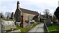
Llansantffraid church Aberkenfig
View of Llansantffraid church Aberkenfig off the old road
Image: © Colin Prosser
Taken: 17 Feb 2013
0.05 miles
7
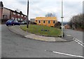
Beulah Mission Hall, Aberkenfig
Viewed across Bridgend Road south of the B4281. The place of worship is a corrugated metal building.
Image: © Jaggery
Taken: 27 Mar 2013
0.05 miles
8
Beulah Chapel
Beaulah Chapel, Bridgend Road, Aberkenfig.
Image: © Colin Prosser
Taken: 9 May 2023
0.05 miles
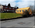
9
Pleasant View, Aberkenfig
The houses are in Pleasant View. The conspicuous building is Beulah Mission Hall. http://www.geograph.org.uk/photo/3395225
Image: © Jaggery
Taken: 27 Mar 2013
0.05 miles
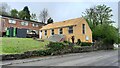
10
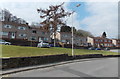
Pleasant View houses, Aberkenfig
Pleasant View is set back from the west side of Bridgend Road.
The houses have views across the valley of the Ogmore River. http://www.geograph.org.uk/photo/3384700
Image: © Jaggery
Taken: 27 Mar 2013
0.06 miles