IMAGES TAKEN NEAR TO
Bettws, BRIDGEND, CF32 8UL
Introduction
This page details the photographs taken nearby to CF32 8UL by members of the Geograph project.
The Geograph project started in 2005 with the aim of publishing, organising and preserving representative images for every square kilometre of Great Britain, Ireland and the Isle of Man.

There are currently over 7.5m images from over14,400 individuals and you can help contribute to the project by visiting https://www.geograph.org.uk
Image Map
Images are licensed for reuse under creativecommons.org/licenses/by-sa/2.0
Notes
- Clicking on the map will re-center to the selected point.
- The higher the marker number, the further away the image location is from the centre of the postcode.
Image Listing (23 Images Found)
Images are licensed for reuse under creativecommons.org/licenses/by-sa/2.0
Image
Details
Distance
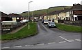
2
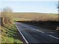
Road heading north of Bettws
Looking across to Pen y Foel. Just out of shot to the right is the stile for the footpath leading towards Llangeinor.
Image: © John Light
Taken: 13 Jan 2012
0.07 miles
3
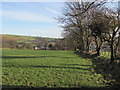
Public footpath north of Bettws
The footpath hugs the right hand edge of this field, which is attractively lined with mature trees. Hidden by the trees is Llangeinor.
Image: © John Light
Taken: 13 Jan 2012
0.09 miles
4
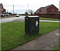
Virgin Media telecoms cabinet, Heol Glannant, Bettws
The cabinet is numbered 10. A BT telecoms cabinet is nearby. http://www.geograph.org.uk/photo/5618854
Image: © Jaggery
Taken: 2 Dec 2017
0.13 miles
5
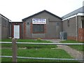
BT telecoms cabinet on a Bettws corner
On the corner of Y Wern and Heol Glannant. A Virgin Media telecoms cabinet is nearby. http://www.geograph.org.uk/photo/5618849
Image: © Jaggery
Taken: 2 Dec 2017
0.14 miles
7
Tyn y Waun, Bettws
Tyn y Waun is a cul-de-sac on the east side of the road named Waunfach.
Image: © Jaggery
Taken: 2 Dec 2017
0.15 miles
8
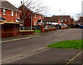
Y Wern towards shops, Bettws
Viewed across Heol Glannant looking west along Y Wern towards a row of shops which includes the village post office. http://www.geograph.org.uk/photo/5615996
Image: © Jaggery
Taken: 2 Dec 2017
0.16 miles
9
Bryn Awel, Bettws
Looking north along Bryn Awel from Heol Glannant. The left turn ahead near the van is into Pen y Mynydd.
Image: © Jaggery
Taken: 2 Dec 2017
0.17 miles
10
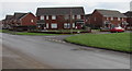
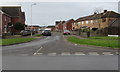
Junction of Waunfach and Heol Glannant, Bettws
Waunfach from the right joins Heol Glannant.
Image: © Jaggery
Taken: 2 Dec 2017
0.20 miles