IMAGES TAKEN NEAR TO
Bettws, BRIDGEND, CF32 8TA
Introduction
This page details the photographs taken nearby to CF32 8TA by members of the Geograph project.
The Geograph project started in 2005 with the aim of publishing, organising and preserving representative images for every square kilometre of Great Britain, Ireland and the Isle of Man.

There are currently over 7.5m images from over14,400 individuals and you can help contribute to the project by visiting https://www.geograph.org.uk
Image Map
Images are licensed for reuse under creativecommons.org/licenses/by-sa/2.0
Notes
- Clicking on the map will re-center to the selected point.
- The higher the marker number, the further away the image location is from the centre of the postcode.
Image Listing (71 Images Found)
Images are licensed for reuse under creativecommons.org/licenses/by-sa/2.0
Image
Details
Distance
1

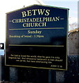
Betws Christadelphian Church, Bettws
On the east side of Bettws Road. The church name is the Welsh spelling Betws whereas the village is usually known as Bettws in English. In November 2017, the nearby information board http://www.geograph.org.uk/photo/5609071 shows that breaking of bread here is on Sundays from 3:30pm.
Image: © Jaggery
Taken: 24 Nov 2017
0.01 miles
2
Betws Christadelphian Church information board
At the entrance to this http://www.geograph.org.uk/photo/5609066 church.
Image: © Jaggery
Taken: 24 Nov 2017
0.01 miles
3
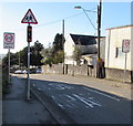
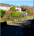
Start of the 20 zone, Bettws Road, Bettws
The 30mph speed limit drops to 20mph on the approach to a school. PARTH is Welsh for ZONE.
Image: © Jaggery
Taken: 24 Nov 2017
0.01 miles
4

Oddfellows name sign, Bettws
Faded in November 2017, the sign is on the right side of the village pub. http://www.geograph.org.uk/photo/5609101
Image: © Jaggery
Taken: 24 Nov 2017
0.02 miles
5
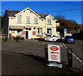
Oddfellows in Bettws
Village pub on the corner of Heol Dewi Sant and Heol Richard Price.
Image: © Jaggery
Taken: 24 Nov 2017
0.02 miles
6
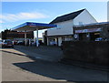
Bettws Service Station, Bettws
The Heol Dewi Sant side of the service station on the corner of Bettws Road.
In November 2017, the name on the canopy over the fuel pumps is Pace.
Image: © Jaggery
Taken: 24 Nov 2017
0.03 miles
7
Traffic calming on Heol Richard Price, Bettws
Traffic on the camera side has priority through the narrowing of the roadway.
Image: © Jaggery
Taken: 24 Nov 2017
0.03 miles
8

Valley and Vale Community Arts, Bettws
In Sardis Media Centre on the right. Sardis Baptist Chapel is on the left.
Image: © Jaggery
Taken: 24 Nov 2017
0.04 miles
9

Sardis Baptist Chapel, Heol Dewi Sant, Bettws
This is the 1865 rebuild of the original chapel erected in 1836.
Image: © Jaggery
Taken: 24 Nov 2017
0.04 miles
10
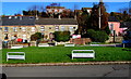
Houses on the north side of the village green, Heol Dewi Sant, Bettws
See https://www.geograph.org.uk/photo/5641934 for another view of the green and some historical notes.
Image: © Jaggery
Taken: 24 Nov 2017
0.05 miles