IMAGES TAKEN NEAR TO
Pontycymer, BRIDGEND, CF32 8NP
Introduction
This page details the photographs taken nearby to CF32 8NP by members of the Geograph project.
The Geograph project started in 2005 with the aim of publishing, organising and preserving representative images for every square kilometre of Great Britain, Ireland and the Isle of Man.

There are currently over 7.5m images from over14,400 individuals and you can help contribute to the project by visiting https://www.geograph.org.uk
Image Map
Images are licensed for reuse under creativecommons.org/licenses/by-sa/2.0
Notes
- Clicking on the map will re-center to the selected point.
- The higher the marker number, the further away the image location is from the centre of the postcode.
Image Listing (107 Images Found)
Images are licensed for reuse under creativecommons.org/licenses/by-sa/2.0
Image
Details
Distance
2
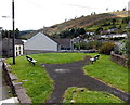
Benches alongside a path in Pontycymer
Alongside a path from Hill View to Waun Bant. http://www.geograph.org.uk/photo/4149951
Image: © Jaggery
Taken: 1 Sep 2014
0.01 miles
3
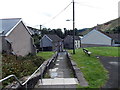
Path from Hill View to Waun Bant, Pontycymer
Looking south towards Waun Bant. A green area with two benches is on the right. http://www.geograph.org.uk/photo/4149946
Image: © Jaggery
Taken: 1 Sep 2014
0.02 miles
4
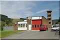
Pontycymmer Fire Station
Pontycymmer Fire Station, Victoria Street, Pontycymmer is part of South Wales Fire & Rescue Service
Image: © Kevin Hale
Taken: 5 Jun 2007
0.02 miles
5
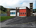
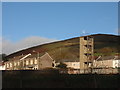
Pontycymer Fire Station and tower
The fire station's address is Victoria Street (the A4064) though the main entrance is here, from Hill View. Officially opened on June 5th 1972, the station serves the Garw Valley (north of Bridgend) from Bettws in the south to Blaengarw at the northern end of the valley. The station name shows both PONTYCYMMER and PONTYCYMER. The latter spelling is the Welsh language name of the village,
which is now (2014) also widely used in English.
Image: © Jaggery
Taken: 1 Sep 2014
0.02 miles
6
West along Waun Bant, Pontycymer
A nearby street name sign shows Waun Bant http://www.geograph.org.uk/photo/4162928 whereas
the one at the far end of the street shows Gwaun Bant. http://www.geograph.org.uk/photo/4162924
Image: © Jaggery
Taken: 6 Sep 2014
0.03 miles
7
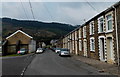
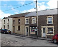
Semi-detached houses on a corner in Pontycymer
On the corner of the A4064 and Waun Bant.
Image: © Jaggery
Taken: 1 Sep 2014
0.03 miles
8
Yellow grit box at a bend in Hill View, Pontycymer
The contents of the grit box are used to treat the road surface in icy or snowy weather.
Image: © Jaggery
Taken: 1 Sep 2014
0.03 miles
9
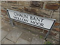
One street, two Welsh names, Pontycymer
The name sign here at the western end of the street shows Gwaun Bant.
The name sign at the eastern end of the street shows Waun Bant. http://www.geograph.org.uk/photo/4162928
Image: © Jaggery
Taken: 6 Sep 2014
0.04 miles
10
Waun Bant Fish Bar in Pontycymer
There is no nameboard on this fish and chips shop in the street named Waun Bant. An illuminated sign in the window on the left side of the tall wooden pole depicts a fish and shows FISH CHIPS.
Image: © Jaggery
Taken: 1 Sep 2014
0.04 miles