IMAGES TAKEN NEAR TO
King Edward Street, BRIDGEND, CF32 8ND
Introduction
This page details the photographs taken nearby to King Edward Street, CF32 8ND by members of the Geograph project.
The Geograph project started in 2005 with the aim of publishing, organising and preserving representative images for every square kilometre of Great Britain, Ireland and the Isle of Man.

There are currently over 7.5m images from over14,400 individuals and you can help contribute to the project by visiting https://www.geograph.org.uk
Image Map
Images are licensed for reuse under creativecommons.org/licenses/by-sa/2.0
Notes
- Clicking on the map will re-center to the selected point.
- The higher the marker number, the further away the image location is from the centre of the postcode.
Image Listing (37 Images Found)
Images are licensed for reuse under creativecommons.org/licenses/by-sa/2.0
Image
Details
Distance
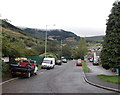
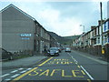
1

King Edward Street bus stop in Blaengarw
Located near the southern edge of Blaengarw, near the Pontycymer boundary.
Painted in yellow on the road surface, SAFLE BYSIAU is Welsh for bus stop.
BYSIAU is Welsh for buses. In some other locations, the singular BWS is used.
Image: © Jaggery
Taken: 15 Aug 2014
0.03 miles
2
Ffaldau Industrial Estate access road, Blaengarw
This road is accessed from the A4064 at the Blaengarw/Pontycymer boundary.
Image: © Jaggery
Taken: 1 Sep 2014
0.04 miles
3
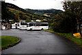
Keith Jones Coaches, Blaengarw
Located at the northern end of Ffaldau Industrial Estate near the southern edge of Blaengarw.
Image: © Jaggery
Taken: 1 Sep 2014
0.04 miles
4
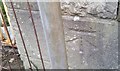
Ordnance Survey Cut Mark
This OS cut mark can be found on the gatepost of the former school. It marks a point 180.935m above mean sea level.
Image: © Adrian Dust
Taken: 29 May 2017
0.06 miles
5
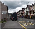
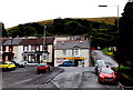
Southern boundary sign, Blaengarw
Heading north, the A4064 passes from Pontycymer into Blaengarw.
Image: © Jaggery
Taken: 15 Aug 2014
0.06 miles
6
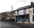
Abandoned shop in Blaengarw
Stock on shelves can be seen through the window of the dark blue shop frontage in King Edward Street.
Image: © Jaggery
Taken: 1 Sep 2014
0.06 miles
7
Southern edge of Blaengarw
Looking up from the access road to Ffaldau Industrial Estate. The shop is at the southern edge of Blaengarw. The Pontycymer boundary sign http://www.geograph.org.uk/photo/4120170 is behind the trees on the right.
Image: © Jaggery
Taken: 1 Sep 2014
0.06 miles
8
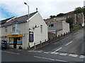
Bryn Stores in Blaengarw
The Premier Express store at 1-3 King Edward Street is the southernmost shop
in Blaengarw, located a few metres from the northern boundary of Pontycymer.
Image: © Jaggery
Taken: 1 Sep 2014
0.06 miles
9
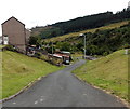
Road into the Garw valley, Blaengarw
The road descends from the A4064 King Edward Street towards a river, Afon Garw.
Image: © Jaggery
Taken: 15 Aug 2014
0.07 miles
10
King Edward Street at Blengarw village boundary
Image: © Colin Pyle
Taken: 15 Jul 2012
0.07 miles