IMAGES TAKEN NEAR TO
Hill View, BRIDGEND, CF32 8LU
Introduction
This page details the photographs taken nearby to Hill View, CF32 8LU by members of the Geograph project.
The Geograph project started in 2005 with the aim of publishing, organising and preserving representative images for every square kilometre of Great Britain, Ireland and the Isle of Man.

There are currently over 7.5m images from over14,400 individuals and you can help contribute to the project by visiting https://www.geograph.org.uk
Image Map
Images are licensed for reuse under creativecommons.org/licenses/by-sa/2.0
Notes
- Clicking on the map will re-center to the selected point.
- The higher the marker number, the further away the image location is from the centre of the postcode.
Image Listing (91 Images Found)
Images are licensed for reuse under creativecommons.org/licenses/by-sa/2.0
Image
Details
Distance
1
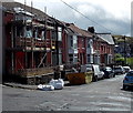
Hill View houses, Pontycymer
Houses on the east side of Hill View, viewed from the corner of St David Street.
Image: © Jaggery
Taken: 1 Sep 2014
0.01 miles
2
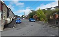
North along Hill View, Pontycymer
Looking north (more exactly NNW) from a bend in the road. http://www.geograph.org.uk/photo/4149926
Image: © Jaggery
Taken: 1 Sep 2014
0.01 miles
3
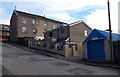
Recently-built house, St David Street, Pontycymer
At the start of September 2014, a FOR SALE sign is outside a house which did not exist at the June 2011 date of a Google Earth Street View, which shows a bare brick and stone building of a different shape here, with all its windows blocked up.
Image: © Jaggery
Taken: 1 Sep 2014
0.03 miles
4
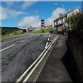
Up towards the fire station, Pontycymer
The A4064 Victoria Street ascends from the corner of Waun Bant towards the fire station tower. http://www.geograph.org.uk/photo/4149793
Image: © Jaggery
Taken: 1 Sep 2014
0.04 miles
5
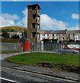
Fire station tower in Pontycymer
Viewed across the A4064 Victoria Street. The fire station's main entrance is from Hill View. http://www.geograph.org.uk/photo/4149773
Image: © Jaggery
Taken: 1 Sep 2014
0.04 miles
6
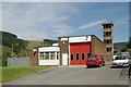
Pontycymmer Fire Station
Pontycymmer Fire Station, Victoria Street, Pontycymmer is part of South Wales Fire & Rescue Service
Image: © Kevin Hale
Taken: 5 Jun 2007
0.04 miles
7
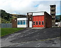
Pontycymer Fire Station and tower
The fire station's address is Victoria Street (the A4064) though the main entrance is here, from Hill View. Officially opened on June 5th 1972, the station serves the Garw Valley (north of Bridgend) from Bettws in the south to Blaengarw at the northern end of the valley. The station name shows both PONTYCYMMER and PONTYCYMER. The latter spelling is the Welsh language name of the village,
which is now (2014) also widely used in English.
Image: © Jaggery
Taken: 1 Sep 2014
0.04 miles
8
Royal Mail van in Pontycymer
The red van is parked in St David Street. The brick wall is the southern edge of St David's Church. http://www.geograph.org.uk/photo/4148555
Image: © Jaggery
Taken: 1 Sep 2014
0.04 miles
9
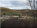
Pontycymer, Fforch-Wen and Mynydd Llangeinwyr
View across the Garw valley towards Pontycymer, with the valley of Fforch-Wen and Mynydd Llangeinwyr in the background.
Image: © Alan Hughes
Taken: 13 Nov 2017
0.05 miles
10
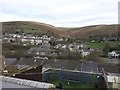
Pontycymer
View of Pontycymer from the footpath leading up into Garw Forest.
Image: © Alan Hughes
Taken: 13 Nov 2017
0.05 miles