IMAGES TAKEN NEAR TO
Pleasant View, BRIDGEND, CF32 8BJ
Introduction
This page details the photographs taken nearby to Pleasant View, CF32 8BJ by members of the Geograph project.
The Geograph project started in 2005 with the aim of publishing, organising and preserving representative images for every square kilometre of Great Britain, Ireland and the Isle of Man.

There are currently over 7.5m images from over14,400 individuals and you can help contribute to the project by visiting https://www.geograph.org.uk
Image Map
Images are licensed for reuse under creativecommons.org/licenses/by-sa/2.0
Notes
- Clicking on the map will re-center to the selected point.
- The higher the marker number, the further away the image location is from the centre of the postcode.
Image Listing (30 Images Found)
Images are licensed for reuse under creativecommons.org/licenses/by-sa/2.0
Image
Details
Distance
1
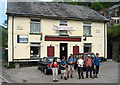
Tafarn Braich y Cymer / Braich y Cymmer Inn
Cerddwyr y tu fas i Dafarn Braich y Cymer. Fe'i henwyd ar ol ffarm gerllaw.
Walkers outside a public house known as Braich y Cymmer < cymer (trans. ridge above the [river] confluence). The pub is named after a nearby farm.
Image: © Alan Richards
Taken: 19 Jun 2005
0.01 miles
2
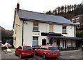
Braich y Cymmer
The Braich y Cymmer at Point y Rhyl.
Image: © Alan Hughes
Taken: 19 Jan 2017
0.02 miles
3
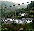
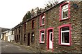
Houses in the Garw Valley, Pontyrhyl
Beech Road houses viewed from the A4064 north of Lluest.
I could not find a spot for a similar photo that did not show the black cable across the view.
Image: © Jaggery
Taken: 6 Sep 2014
0.02 miles
4
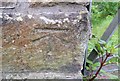
Ordnance Survey Cut Mark
This OS cut mark can be found on the SE parapet of the bridge. It marks a point 120.506m above mean sea level.
Image: © Adrian Dust
Taken: 29 May 2017
0.03 miles
5
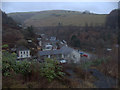
Where the Garw Fechan joins the main Garw river
The large building is the Braich y Cymmer public house
Image: © John Finch
Taken: 9 Mar 2015
0.03 miles
6
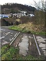
Disused Railway
Tracks of a disused railway at Lluest.
Image: © Alan Hughes
Taken: 19 Jan 2017
0.05 miles
7
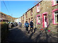
Teras Garw Fechan / Garw Fechan Terrace
Cerddwyr yn mynd heibio i Deras Garw Fechan.
Walkers passing Garw Fechan Terrace (trans. lesser rough river).
Image: © Alan Richards
Taken: 10 Nov 2019
0.07 miles
8
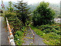
Public footpath descends to the Garw Valley
From the A4064 near the bus shelter seen here. http://www.geograph.org.uk/photo/4159018
Image: © Jaggery
Taken: 6 Sep 2014
0.07 miles
9
Terraced Housing
Terraced housing on Garw Fechan Road.
Image: © Alan Hughes
Taken: 19 Jan 2017
0.08 miles
10
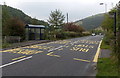
Bus stops and shelter north of Lluest
Alongside the A4064. A green sign near the bus shelter points left
towards a public footpath http://www.geograph.org.uk/photo/4159019 down into the Garw Valley.
Image: © Jaggery
Taken: 6 Sep 2014
0.09 miles