IMAGES TAKEN NEAR TO
Station Street, BRIDGEND, CF32 8BA
Introduction
This page details the photographs taken nearby to Station Street, CF32 8BA by members of the Geograph project.
The Geograph project started in 2005 with the aim of publishing, organising and preserving representative images for every square kilometre of Great Britain, Ireland and the Isle of Man.

There are currently over 7.5m images from over14,400 individuals and you can help contribute to the project by visiting https://www.geograph.org.uk
Image Map
Images are licensed for reuse under creativecommons.org/licenses/by-sa/2.0
Notes
- Clicking on the map will re-center to the selected point.
- The higher the marker number, the further away the image location is from the centre of the postcode.
Image Listing (100 Images Found)
Images are licensed for reuse under creativecommons.org/licenses/by-sa/2.0
Image
Details
Distance
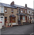
1
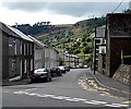
Station Street, Blaengarw
Station Street descends from the A4064, into the Garw Valley. This was a route to Blaengarw railway station, formerly the northern terminus of the Garw Valley line. Passenger services ended in 1953.
Image: © Jaggery
Taken: 15 Aug 2014
0.01 miles
2
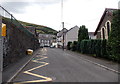
Zigzag road markings, Church Place, Blaengarw
The yellow lines mark a no parking or stopping zone outside Blaengarw Primary School. The bilingual text on the road ahead shows SCHOOL KEEP CLEAR and its Welsh language equivalent.
Image: © Jaggery
Taken: 15 Aug 2014
0.02 miles
3
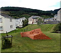
Mining Memorial in Blaengarw
Located on the west side of Nanthir Road, one of several memorials to miners and mining in the former mining village.
Image: © Jaggery
Taken: 15 Aug 2014
0.02 miles
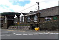
4
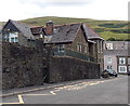
Side entrance to Blaengarw Primary School
From Church Place, Blaengarw. The main entrances are around the corner, in Station Street.
Image: © Jaggery
Taken: 15 Aug 2014
0.03 miles
5
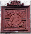
Queen Victoria Diamond Jubilee tablet in Blaengarw
On the Station Street wall of Clwb Calon Lân. http://www.geograph.org.uk/photo/4120866 Dated 1897, the tablet lists the areas over which Victoria ruled. EGYPT is listed as well as AFRICA, and BURMAH is so spelt.
Image: © Jaggery
Taken: 15 Aug 2014
0.03 miles
6
East side of Blaengarw Primary School
Viewed across Station Street, Blaengarw.
Image: © Jaggery
Taken: 15 Aug 2014
0.03 miles
7
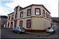
Clwb Calon L?n, Blaengarw
Club on the corner of Station Street and Church Street. Old maps show Blaengarw railway station nearby, formerly the northern terminus of the Garw Valley line. Passenger services ended in 1953.
Image: © Jaggery
Taken: 15 Aug 2014
0.04 miles
8
Valley view towards Clwb Calon L?n, Blaengarw
Looking across the Garw Valley towards Clwb Calon Lân http://www.geograph.org.uk/photo/4120866 on the right.
Image: © Jaggery
Taken: 15 Aug 2014
0.04 miles
9
Church Street houses, Blaengarw
The bellcote on the right is on the former St James Church. http://www.geograph.org.uk/photo/4120958
Image: © Jaggery
Taken: 15 Aug 2014
0.04 miles
10
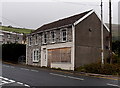
Boarded-up former shop in Blaengarw
Viewed across the A4064 from the corner of Station Street.
Image: © Jaggery
Taken: 1 Sep 2014
0.04 miles