IMAGES TAKEN NEAR TO
Brynogwy Terrace, BRIDGEND, CF32 7ST
Introduction
This page details the photographs taken nearby to Brynogwy Terrace, CF32 7ST by members of the Geograph project.
The Geograph project started in 2005 with the aim of publishing, organising and preserving representative images for every square kilometre of Great Britain, Ireland and the Isle of Man.

There are currently over 7.5m images from over14,400 individuals and you can help contribute to the project by visiting https://www.geograph.org.uk
Image Map
Images are licensed for reuse under creativecommons.org/licenses/by-sa/2.0
Notes
- Clicking on the map will re-center to the selected point.
- The higher the marker number, the further away the image location is from the centre of the postcode.
Image Listing (66 Images Found)
Images are licensed for reuse under creativecommons.org/licenses/by-sa/2.0
Image
Details
Distance
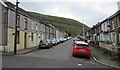
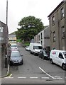
1
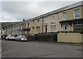
Oakfield Terrace houses, Nantymoel
Houses on the east side of Oakfield Terrace viewed looking north from the corner of Hill Street.
Image: © Jaggery
Taken: 29 Aug 2018
0.03 miles
2
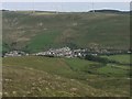
Nantymoel and Windfarm
View over the edge of Nantymoel towards the windfarm on Mynydd Maesteg.
Image: © Alan Hughes
Taken: 18 May 2017
0.03 miles
3
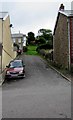
Top of Hill Street, Nantymoel
The eastern end of Hill Street is ahead, near the southern end of John Street.
Image: © Jaggery
Taken: 29 Aug 2018
0.04 miles
4
Towards John Street and the upper end of Cross Street, Nantymoel
Looking east up Cross Street from the Oakfield Terrace crossroads.
Image: © Jaggery
Taken: 29 Aug 2018
0.04 miles
5
South along Oakfield Terrace, Nantymoel
From Cross Street.
Image: © Jaggery
Taken: 29 Aug 2018
0.05 miles
6
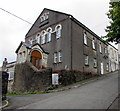
Former Bethany Chapel in Price Town, Nantymoel
The building on the north side of Hill Street is in residential use in 2018.
The tablet on the pediment shows AD BETHANY 1905/ ENGLISH CALVINISTIC METHODIST/ CHAPEL
Image: © Jaggery
Taken: 29 Aug 2018
0.05 miles
7
Up Hill Street, Nantymoel
Hill Street ascends from Ogwy Street towards the Oakfield Terrace intersection.
Image: © Jaggery
Taken: 29 Aug 2018
0.05 miles
8
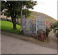
Hill Street electricity substation, Nantymoel
The Western Power Distribution electricity substation is located behind the tree here https://www.geograph.org.uk/photo/5888247
The substation identifier is ABER S/S 563667
Image: © Jaggery
Taken: 29 Aug 2018
0.06 miles
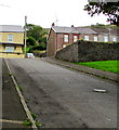
9
Hill Street, Nantymoel
Ascending from the east side of the A4061 Ogwy Street.
Image: © Jaggery
Taken: 29 Aug 2018
0.06 miles
10
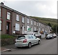
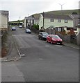
Cars and houses, Oakfield Terrace, Nantymoel
Houses on the east side of Oakfield Terrace viewed looking south from the corner of Hill Street.
Image: © Jaggery
Taken: 29 Aug 2018
0.07 miles