IMAGES TAKEN NEAR TO
Waun Llwyd Terrace, BRIDGEND, CF32 7PP
Introduction
This page details the photographs taken nearby to Waun Llwyd Terrace, CF32 7PP by members of the Geograph project.
The Geograph project started in 2005 with the aim of publishing, organising and preserving representative images for every square kilometre of Great Britain, Ireland and the Isle of Man.

There are currently over 7.5m images from over14,400 individuals and you can help contribute to the project by visiting https://www.geograph.org.uk
Image Map
Images are licensed for reuse under creativecommons.org/licenses/by-sa/2.0
Notes
- Clicking on the map will re-center to the selected point.
- The higher the marker number, the further away the image location is from the centre of the postcode.
Image Listing (83 Images Found)
Images are licensed for reuse under creativecommons.org/licenses/by-sa/2.0
Image
Details
Distance
1
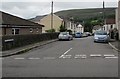
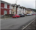
Waun Llwyd Terrace, Nantymoel
Viewed across Waun Wen Terrace. Nantymoel Surgery https://www.geograph.org.uk/photo/5889650 is in the single-storey building on the left.
Image: © Jaggery
Taken: 29 Aug 2018
0.04 miles
2

Road to Nantymoel Primary School, Nantymoel
Descending from the west side of the A4061 Ogwy Street towards
an entrance gate to Nantymoel Primary School in Gwendoline Street.
Image: © Jaggery
Taken: 29 Aug 2018
0.05 miles
3
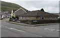
Nantymoel Surgery, Nantymoel
Medical surgery in a single-storey building on the corner of Waun Llwyd Terrace and Waun Wen Terrace.
Image: © Jaggery
Taken: 29 Aug 2018
0.07 miles
4
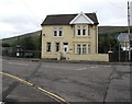
Detached house, Ogwy Street, Nantymoel
The direction sign on the right is 9 miles from Bridgend, 5 miles from the Garw Valley.
Image: © Jaggery
Taken: 29 Aug 2018
0.07 miles
5
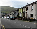
Waun Wen Terrace houses, Nantymoel
Viewed from the southern end of Dinam Street.
Image: © Jaggery
Taken: 29 Aug 2018
0.08 miles
6
Waun Wen Terrace, Nantymoel
The house on the left is on the corner of Waun Llwyd Terrace. https://www.geograph.org.uk/photo/5889682
Image: © Jaggery
Taken: 29 Aug 2018
0.08 miles
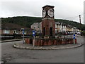
7
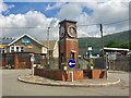
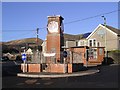
Clock tower, Nantymoel
The clock tower stands on the A4061 in Nantymoel, where the road turns sharply uphill towards Treorchy. A war memorial, it was unveiled in September 1955.
Image: © Alan Hughes
Taken: 10 Jul 2019
0.08 miles
8
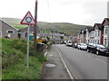
Warning sign - roundabout, Waun Wen Terrace, Nantymoel
On the approach to the roundabout at the A4061 junction.
Image: © Jaggery
Taken: 29 Aug 2018
0.08 miles
10
War Memorial Clock Tower, Nantymoel
Nantymoel Memorial Clock Tower was official unveiled on September 3rd 1955.
It was built by Hartland Brothers with funds from Wyndham Medical Aid Society on its dissolution.
Image: © Jaggery
Taken: 29 Aug 2018
0.08 miles