IMAGES TAKEN NEAR TO
Cwrt Pant Yr Awel, BRIDGEND, CF32 7HW
Introduction
This page details the photographs taken nearby to Cwrt Pant Yr Awel, CF32 7HW by members of the Geograph project.
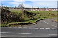
The Geograph project started in 2005 with the aim of publishing, organising and preserving representative images for every square kilometre of Great Britain, Ireland and the Isle of Man.

There are currently over 7.5m images from over14,400 individuals and you can help contribute to the project by visiting https://www.geograph.org.uk
Image Map
Images are licensed for reuse under creativecommons.org/licenses/by-sa/2.0
Notes
- Clicking on the map will re-center to the selected point.
- The higher the marker number, the further away the image location is from the centre of the postcode.
Image Listing (44 Images Found)
Images are licensed for reuse under creativecommons.org/licenses/by-sa/2.0
Image
Details
Distance
1
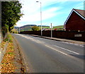
Towards the end of the pavement, Blackmill Road, Lewistown
The pavement on the left (west) side of the A4061 peters out ahead.
Walkers can use the pavement on the Pant yr Awel Court side of the road.
Image: © Jaggery
Taken: 31 Oct 2018
0.03 miles
2
Pant yr Awel Court, Lewistown
Cul-de-sac on the east side of the A4061 Blackmill Road.
Image: © Jaggery
Taken: 31 Oct 2018
0.03 miles
3
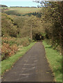
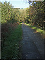
The Ogmore Valley cycle path seen near Lewistown
This path for cyclists and walkers follows the course of the valley’s former railway line. The stretch of the path between Blackmill and Nant-y-moel, on which the photograph was taken, makes up Route 883 of the National Cycle Network.
Image: © eswales
Taken: 25 Oct 2013
0.07 miles
4
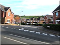
Keep left sign on a pedestrian refuge in Lewistown
In the middle of the A4061 Blackmill Road.
Image: © Jaggery
Taken: 31 Oct 2018
0.08 miles
5
Cycle path by Pant-yr-awel and Lewistown
A long, straight section of the Ogmore Valley’s path for cyclists and walkers which follows the course of a dismantled railway line. Here, north of Blackmill the path is Route 883 of the National Cycle Network.
Image: © eswales
Taken: 25 Oct 2013
0.08 miles
6
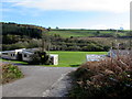
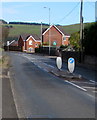
Access road to sports fields in Lewistown
From the east side of Blackmill Road to sports fields on flat land on a bank of the Ogwr Fawr river.
Image: © Jaggery
Taken: 31 Oct 2018
0.09 miles
7
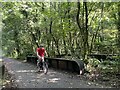
Cyclist on track 883
The iron bridge structure is an indication that this cycle track was once a railway.
Image: © Alan Hughes
Taken: 3 Sep 2023
0.10 miles
8
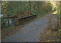
Old railway bridge over the River Ogmore, Lewistown
One of several spots north of Blackmill where the Ogmore Valley’s former railway line crossed the river. The bridge now lies on the valley’s cycle path – or ‘community route’ – which follows the course of the dismantled line.
Image: © eswales
Taken: 25 Oct 2013
0.10 miles
9
Steel Bridge
The heavy steelwork of this bridge over the river Ogwr is a reminder that it once carried a railway. Now a cycle track / footpath.
Image: © Alan Hughes
Taken: 18 May 2017
0.11 miles
10
Long row of houses, Pentre Beili Terrace, Lewistown
Viewed from Blackmill Road near the Lynn Davies Avenue junction.
Image: © Jaggery
Taken: 31 Oct 2018
0.11 miles