IMAGES TAKEN NEAR TO
Alma Terrace, BRIDGEND, CF32 7HS
Introduction
This page details the photographs taken nearby to Alma Terrace, CF32 7HS by members of the Geograph project.
The Geograph project started in 2005 with the aim of publishing, organising and preserving representative images for every square kilometre of Great Britain, Ireland and the Isle of Man.

There are currently over 7.5m images from over14,400 individuals and you can help contribute to the project by visiting https://www.geograph.org.uk
Image Map
Images are licensed for reuse under creativecommons.org/licenses/by-sa/2.0
Notes
- Clicking on the map will re-center to the selected point.
- The higher the marker number, the further away the image location is from the centre of the postcode.
Image Listing (78 Images Found)
Images are licensed for reuse under creativecommons.org/licenses/by-sa/2.0
Image
Details
Distance
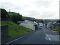
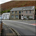
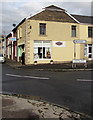
2
On-street parking, Alma Terrace, Ogmore Vale
Viewed across the A4061. The Alma Terrace name sign is on the right.
Image: © Jaggery
Taken: 14 Nov 2018
0.01 miles
3
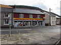
Ogmore Vale Convenience Store
At 21 Cemetery Road in Ogmore Vale, viewed across the A4061.
Image: © Jaggery
Taken: 14 Nov 2018
0.02 miles
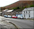
4
Houses and hillside, Ogmore Vale
Houses at the southern end of Walters Road viewed across the A4061 in November 2018.
Image: © Jaggery
Taken: 14 Nov 2018
0.02 miles
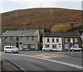
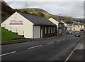
5
Bend in the A4061, Ogmore Vale
The A4061 Bridge Street is behind the camera. Ahead on the A4061 Cemetery Road for Bridgend.
Image: © Jaggery
Taken: 14 Nov 2018
0.02 miles
6
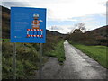
Welsh Water notice alongside a path, Ogmore Vale
Alongside a combined footpath/cycleway south of Bridge Street viewed in November 2018. The notice shows "To do the work safely, we'll need to temporarily close a section of the cycle track between Ogmore Vale and Lewistown." The text is also in Welsh. Old maps show a railway here.
Image: © Jaggery
Taken: 14 Nov 2018
0.03 miles
7
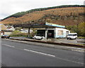
Derelict former fuel filling station and shop in Ogmore Vale
Alongside the A4061 Cemetery Road viewed in November 2018. This site has been derelict for many years.
A June 2011 Google Earth Street View shows boarded-up premises here with four fuel pumps still in place.
Image: © Jaggery
Taken: 14 Nov 2018
0.03 miles
8
Elite Property estate agents office in Ogmore Vale
In November 2018 this is the only estate/letting agents based in Ogmore Vale.
Image: © Jaggery
Taken: 14 Nov 2018
0.03 miles
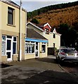
9
Daisy Chains Florist, Ogmore Vale
At 2 Walters Road, one mile from Wyndham.
Image: © Jaggery
Taken: 14 Nov 2018
0.03 miles
10
LC Martial Arts name sign, Cemetery Road, Ogmore Vale
In November 2018 the name sign shows The Home of Nantymoel Tang Soo Do.
A June 2011 Google Earth Street View shows a Kingdom Hall of Jehovah's Witnesses in this building.
Image: © Jaggery
Taken: 14 Nov 2018
0.04 miles