IMAGES TAKEN NEAR TO
Corbett Street, BRIDGEND, CF32 7AA
Introduction
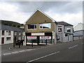
This page details the photographs taken nearby to Corbett Street, CF32 7AA by members of the Geograph project.
The Geograph project started in 2005 with the aim of publishing, organising and preserving representative images for every square kilometre of Great Britain, Ireland and the Isle of Man.

There are currently over 7.5m images from over14,400 individuals and you can help contribute to the project by visiting https://www.geograph.org.uk
Image Map
Images are licensed for reuse under creativecommons.org/licenses/by-sa/2.0
Notes
- Clicking on the map will re-center to the selected point.
- The higher the marker number, the further away the image location is from the centre of the postcode.
Image Listing (156 Images Found)
Images are licensed for reuse under creativecommons.org/licenses/by-sa/2.0
Image
Details
Distance
1
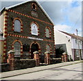
Christchurch, Corbett Street, Ogmore Vale
In August 2018 Christchurch is a shared Methodist/United Reformed church.
The building was erected in 1907 as Bethel Primitive Methodist Church. https://www.geograph.org.uk/photo/5884911
Image: © Jaggery
Taken: 25 Aug 2018
0.02 miles
2
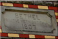
Bethel Primitive Methodist Church 1907 inscription, Ogmore Vale
On the wall here. https://www.geograph.org.uk/photo/5884905
Image: © Jaggery
Taken: 25 Aug 2018
0.02 miles
3

Ogmore Vale Non Political Club
Social club at 5-6 High Street in Ogmore Vale.
Image: © Jaggery
Taken: 25 Aug 2018
0.02 miles
4
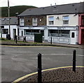
Shorty's in Ogmore Vale
Coffee shop & restaurant at 15 High Street.
Image: © Jaggery
Taken: 25 Aug 2018
0.03 miles
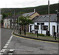
5
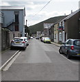
South along Corbett Street, Ogmore Vale
Christchurch https://www.geograph.org.uk/photo/5884905 is ahead on the right.
Image: © Jaggery
Taken: 25 Aug 2018
0.03 miles
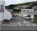
6
Corner shop to rent in Ogmore Vale
On the corner of High Street and the A4061 viewed in late August 2018.
A June 2011 Google Earth Street View shows Hel's Kitchen on this corner.
Image: © Jaggery
Taken: 25 Aug 2018
0.03 miles
7
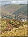
View across Ogmore Vale
The Ogmore valley runs from north to south. At the old mining community of Ogmore Vale tributaries from the west, Cwm Cyffog, and from the east, Cwm Nant y Fuwch, flow into the River Ogwr.
Image: © Alan Hughes
Taken: 20 Oct 2020
0.03 miles
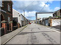
8
West along Corbett Street, Ogmore Vale
Viewed across the A4061 Bethania Row. PONT WAN is Welsh for WEAK BRIDGE.
Image: © Jaggery
Taken: 23 Aug 2018
0.03 miles
9
North along Corbett Street, Ogmore Vale
Christchurch https://www.geograph.org.uk/photo/5884905 is on the left.
Image: © Jaggery
Taken: 25 Aug 2018
0.03 miles
10
Enigma in Ogmore Vale
High Street hairdressers at the edge of a row of houses.
Image: © Jaggery
Taken: 25 Aug 2018
0.04 miles