IMAGES TAKEN NEAR TO
Happy Valley Caravan Park, BRIDGEND, CF32 0NG
Introduction
This page details the photographs taken nearby to Happy Valley Caravan Park, CF32 0NG by members of the Geograph project.
The Geograph project started in 2005 with the aim of publishing, organising and preserving representative images for every square kilometre of Great Britain, Ireland and the Isle of Man.

There are currently over 7.5m images from over14,400 individuals and you can help contribute to the project by visiting https://www.geograph.org.uk
Image Map
Images are licensed for reuse under creativecommons.org/licenses/by-sa/2.0
Notes
- Clicking on the map will re-center to the selected point.
- The higher the marker number, the further away the image location is from the centre of the postcode.
Image Listing (29 Images Found)
Images are licensed for reuse under creativecommons.org/licenses/by-sa/2.0
Image
Details
Distance
1
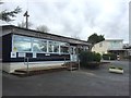
Happy Valley
Entrance to Happy Valley caravan park, Wig Fach.
Image: © Alan Hughes
Taken: 23 Jan 2016
0.05 miles
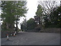
3
Wig Fach Road
Wig Fach caravan site (left) with road leading to A4106.
Image: © Alan Hughes
Taken: 23 Jan 2016
0.06 miles
4
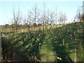
Young trees north east of Wig Fach
This plantation beside the road to Wig Fach lies immediately to the north of - and so should extend - a large established area of deciduous woodland.
Image: © eswales
Taken: 12 Jan 2022
0.08 miles
5
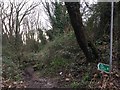
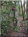
Public Footpath
A public footpath for hobbits?
Image: © Alan Hughes
Taken: 23 Jan 2016
0.11 miles
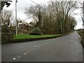
6
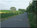
The road to Wig-Fach
A view of some of the straight section of this road immediately to the south of its junction with the A4106. Arable farmland lies to the east of this stretch of road; caravanning and camping areas to the west.
Image: © eswales
Taken: 26 May 2010
0.11 miles
7
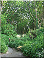
The start of a footpath by the road to Wig-Fach
The start of a footpath which runs through a wooded area to the duneland of Merthyr Mawr Warren.
Image: © eswales
Taken: 26 May 2010
0.11 miles
8
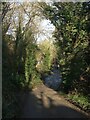
The road to Wig Fach (3)
Much of the road/public footpath is tree-lined, and an area of deciduous woodland lies immediately to its east.
Image: © eswales
Taken: 12 Jan 2022
0.12 miles
9
Ivy Curtain
A curtain of ivy in woodland near Wig Fach.
Image: © Alan Hughes
Taken: 23 Jan 2016
0.15 miles
10
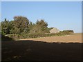
Field boundary by Wig Fach
Part of the boundary of an arable field viewed from a wood just to the east of Wig Fach.
Image: © eswales
Taken: 25 Sep 2015
0.15 miles