IMAGES TAKEN NEAR TO
Laleston, BRIDGEND, CF32 0HY
Introduction
This page details the photographs taken nearby to CF32 0HY by members of the Geograph project.
The Geograph project started in 2005 with the aim of publishing, organising and preserving representative images for every square kilometre of Great Britain, Ireland and the Isle of Man.

There are currently over 7.5m images from over14,400 individuals and you can help contribute to the project by visiting https://www.geograph.org.uk
Image Map
Images are licensed for reuse under creativecommons.org/licenses/by-sa/2.0
Notes
- Clicking on the map will re-center to the selected point.
- The higher the marker number, the further away the image location is from the centre of the postcode.
Image Listing (67 Images Found)
Images are licensed for reuse under creativecommons.org/licenses/by-sa/2.0
Image
Details
Distance
1
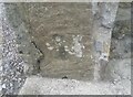
Ordnance Survey Cut Mark
This OS cut mark can be found on the gatepost of No17 Rogers Lane. It marks a point 66.044m above mean sea level.
Image: © Adrian Dust
Taken: 3 Sep 2021
0.02 miles
2

Footpath bypassing a narrow section of Roger's Lane, Laleston
The footpath on the right diverges from the pavementless narrowing road on the left.
The path's far end is in Wind Street, a few metres east of Roger's Lane.
Image: © Jaggery
Taken: 24 Dec 2014
0.03 miles
3

Royal Mail van in Wind Street, Laleston
Viewed from near the Roger's Lane junction.
Image: © Jaggery
Taken: 24 Dec 2014
0.03 miles
4

Western end of Wind Street, Laleston
Viewed across Roger's Lane.
Image: © Jaggery
Taken: 24 Dec 2014
0.03 miles
5

Road narrows signs, Laleston
Alongside Roger's Lane. A CONCEALED ENTRANCE notice is on the post below the sign on the left.
Of more immediate concern to this walker was the absence of a pavement, until I spotted that a path out of shot on the right bypassed this narrow section of road.
Image: © Jaggery
Taken: 24 Dec 2014
0.03 miles
6

Broadway Fach Kiosk electricity substation, Laleston
Viewed across Roger's Lane. The identifier on the Western Power Distribution electricity substation is BROADWAY FACH KIOSK S/S 563803. A small metal label on the right side of the box shows
SOUTH WALES SWITCHGEAR LTD (TRANSFORMERS).
Image: © Jaggery
Taken: 24 Dec 2014
0.04 miles
7

Ordnance Survey Cut Mark
This OS cut mark can be found on the wall of The Vicarage, Rogers Lane. It marks a point 60.866m above mean sea level.
Image: © Adrian Dust
Taken: 3 Sep 2021
0.06 miles
8

Mirror on a Roger's Lane tree near Broadway Farm, Laleston
The mirror increases the range of view of road traffic for the driver of a vehicle in an adjacent driveway.
Image: © Jaggery
Taken: 24 Dec 2014
0.10 miles
9
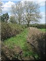
Public footpath at the northern edge of Laleston
A public footpath which has begun at a spot on Wind Street passes between a hedge and a mass of brambles and other vegetation on its way to Roger’s Lane.
Image: © eswales
Taken: 25 Apr 2023
0.12 miles
10
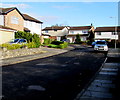
Church View, Laleston
Houses on the east side of Roger's Lane.
Image: © Jaggery
Taken: 24 Dec 2014
0.12 miles