IMAGES TAKEN NEAR TO
Aberkenfig, BRIDGEND, CF32 0EN
Introduction
This page details the photographs taken nearby to CF32 0EN by members of the Geograph project.
The Geograph project started in 2005 with the aim of publishing, organising and preserving representative images for every square kilometre of Great Britain, Ireland and the Isle of Man.

There are currently over 7.5m images from over14,400 individuals and you can help contribute to the project by visiting https://www.geograph.org.uk
Image Map
Images are licensed for reuse under creativecommons.org/licenses/by-sa/2.0
Notes
- Clicking on the map will re-center to the selected point.
- The higher the marker number, the further away the image location is from the centre of the postcode.
Image Listing (40 Images Found)
Images are licensed for reuse under creativecommons.org/licenses/by-sa/2.0
Image
Details
Distance
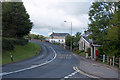
1
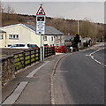
Stop at Fountain level crossing when lights flash
The sign is alongside the B4281 near a left turn which leads to this http://www.geograph.org.uk/photo/3812595 level crossing.
Image: © Jaggery
Taken: 27 Mar 2013
0.02 miles
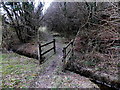
2
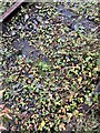
Between the rails
Vegetation on the disused railway track between Tondu and Cefn Cribwr.
Image: © Alan Hughes
Taken: 27 Oct 2020
0.03 miles
3
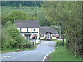
Fountain pub and crossing
Looking South down the lane towards the B4281 junction.
Image: © Chris Shaw
Taken: 16 May 2006
0.03 miles
4
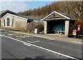
Fountain bus shelter and postbox near Aberkenfig
Alongside the B4281, the road to Cefn Cribwr. The Fountain Restaurant http://www.geograph.org.uk/photo/3384894 is nearby.
Image: © Jaggery
Taken: 27 Mar 2013
0.05 miles
5
Junction of the B4281 at Fountain
The road leads on to Cefn Cribwr and the road to the right to Tondu passing through the Parc Slip nature park which has been created on the footprint of old colliery workings.
Image: © Mick Lobb
Taken: 17 Sep 2010
0.05 miles
6
Nant Cynffig near Fountain level crossing
Viewed from near this http://www.geograph.org.uk/photo/3812595 level crossing.
The stream Nant Cynffig is a tributary of the Ogmore. http://www.geograph.org.uk/photo/3384683
Image: © Jaggery
Taken: 27 Mar 2013
0.05 miles
7
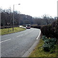
Bus between Aberkenfig and Cefn Cribwr
The First bus is on the B4281 approaching Tycribwr Hill. Next stop is in Cefn Cribwr.
Image: © Jaggery
Taken: 27 Mar 2013
0.06 miles
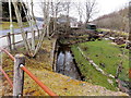
8
Footbridge over Nant Cynffig in Parc Slip
In the SE corner of Parc Slip Nature Reserve.
Image: © Jaggery
Taken: 27 Mar 2013
0.06 miles
9
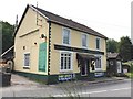
The Fountain Restaurant
The Fountain Restaurant, Aberkenfig.
Image: © Alan Hughes
Taken: 7 Jun 2016
0.07 miles
10
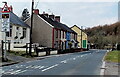
The Fountain
The houses and The Fountain pub, near Aberkenfig
Image: © Colin Prosser
Taken: Unknown
0.07 miles