1
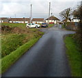
Heol Shon houses, Cefn Cribwr
Viewed from the corner of the B4281, the main road through the village.
The street name sign shows that Heol Shon leads to streets named Gwelfor and Heol Castell.
Image: © Jaggery
Taken: 7 Dec 2012
0.03 miles
2
Damaged bus shelter, Cefn Cribwr
Located on the north side of the B4281, the main road through the village, the wooden section
of the shelter is damaged and a part of it is missing. Is the cause weathering or vandalism?
Image: © Jaggery
Taken: 7 Dec 2012
0.04 miles
3
Ty Fry Road, Cefn Cribwr
Looking north towards the B4281, the main road through the village.
Image: © Jaggery
Taken: 7 Dec 2012
0.05 miles
4
Cefn Cribwr War Memorial
Erected in 2012 at the eastern edge of the village green, this War Memorial has replaced the one located on a bus shelter http://www.geograph.org.uk/photo/3274381 in the village. Designed by Welsh artist Naomi Leake, it is in the shape of a Celtic cross engraved with poppies and doves. Surrounding the cross are 29 stones http://www.geograph.org.uk/photo/3267564 which commemorate the local people who died in the two World Wars.
Image: © Jaggery
Taken: 7 Dec 2012
0.05 miles
5
Corner view of The Farmers Arms, Cefn Cribwr
The pub is on the corner of Cefn Road and Ty Fry Road.
Image: © Jaggery
Taken: 7 Dec 2012
0.05 miles
6
The Farmers Arms, Cefn Cribwr
Viewed across the B4281 Cefn Road, the main road through the village.
The pub is on the corner of Ty Fry Road.
Image: © Jaggery
Taken: 7 Dec 2012
0.05 miles
7
A ring of commemorative stones around Cefn Cribwr War Memorial
The stones encircling the War Memorial http://www.geograph.org.uk/photo/3267547 commemorate
the local people who died in the two World Wars.
Image: © Jaggery
Taken: 7 Dec 2012
0.07 miles
8
Sea View, Cefn Cribwr
Sea View is a long row of houses on the north side of the B4281, the main road through the village. Though the houses are about 6km from the sea, the elevation here is about 125 metres above mean sea level and there are no houses on the opposite side of the road to block the view of the Bristol Channel.
Image: © Jaggery
Taken: 7 Dec 2012
0.07 miles
9
Children's play area, Cefn Cribwr
Located near the eastern end of a recreation area and open space on the south side of the B4281,
the main road through the village.
Image: © Jaggery
Taken: 7 Dec 2012
0.07 miles
10
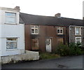
Derelict house, Cefn Road, Cefn Cribwr
Viewed across the B4281 Cefn Road, the main road through the village.
The house's ground floor windows are boarded up and some of the upstairs panes are broken.
Image: © Jaggery
Taken: 7 Dec 2012
0.09 miles


