IMAGES TAKEN NEAR TO
Maes Glas, BRIDGEND, CF32 0AL
Introduction
This page details the photographs taken nearby to Maes Glas, CF32 0AL by members of the Geograph project.
The Geograph project started in 2005 with the aim of publishing, organising and preserving representative images for every square kilometre of Great Britain, Ireland and the Isle of Man.

There are currently over 7.5m images from over14,400 individuals and you can help contribute to the project by visiting https://www.geograph.org.uk
Image Map
Images are licensed for reuse under creativecommons.org/licenses/by-sa/2.0
Notes
- Clicking on the map will re-center to the selected point.
- The higher the marker number, the further away the image location is from the centre of the postcode.
Image Listing (36 Images Found)
Images are licensed for reuse under creativecommons.org/licenses/by-sa/2.0
Image
Details
Distance
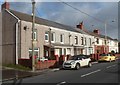
1

Maes Glas, Cefn Cribwr
Maes Glas is a residential cul-de-sac on the north side of the B4281 Cefn Road, the main road through the village.
Image: © Jaggery
Taken: 7 Dec 2012
0.02 miles
2
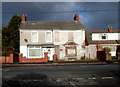
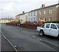
A long-derelict house, Cefn Cribwr
Viewed across Cefn Road from the corner of Woodland Road. The boarded-up house has been derelict for several years.
Image: © Jaggery
Taken: 7 Dec 2012
0.04 miles
3
Corner of Cefn Road and Woodland Road, Cefn Cribwr
Viewed across the B4281 Cefn Road, the main road through the village.
Image: © Jaggery
Taken: 7 Dec 2012
0.06 miles
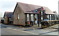
4
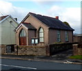
Calvary Baptist Chapel, Cefn Cribwr
The small chapel was built in 1907 on the north side of Cefn Road, opposite the Greenmeadow junction.
Image: © Jaggery
Taken: 7 Dec 2012
0.08 miles
5
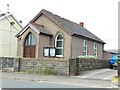
Calvary Baptist Chapel
Calvary Baptist Chapel, Cefn Cribwr.
Image: © Alan Hughes
Taken: 7 Jun 2016
0.08 miles
6
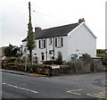
Pleasant View, Cefn Cribwr
Pleasant View is a row of 8 houses on the north side of the B4281 Cefn Road, the main road through the village.
Image: © Jaggery
Taken: 7 Dec 2012
0.08 miles
7
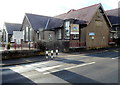
East side of Cefn Cribwr County Primary School
Viewed across the B4281 Cefn Road, the main road through the village. An inscription in stone on the wall on the right side shows CEFN CRIBBWR COUNCIL SCHOOL 1914.
The large notice on the left states that the site is the property of Mid Glamorgan County Council.
That council is now a nonentity. It was abolished in 1996 as a result of the Local Government (Wales) Act 1994 and the area was divided into several authorities. Cefn Cribwr is now part of Bridgend County Borough.
Image: © Jaggery
Taken: 7 Dec 2012
0.08 miles
8
West side of Cefn Cribwr County Primary School
Viewed across the B4281 Cefn Road, the main road through the village.
An inscription in stone on the wall on the left side shows
CEFN CRIBBWR COUNCIL SCHOOL 1914.
Image: © Jaggery
Taken: 7 Dec 2012
0.10 miles
9
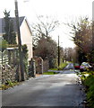
Woodland Road, Cefn Cribwr
A view south from near the corner of the B4281 Cefn Road, the main road through the village.
Image: © Jaggery
Taken: 7 Dec 2012
0.10 miles
10
Heol Newydd, Cefn Cribwr
Viewed from the corner of the B4281 Cefn Road, the main road through the village.
The distant houses are in East Avenue and West Avenue, which with Heol Newydd
make up a T-shaped area of houses, with Heol Newydd as the stem of the T.
Image: © Jaggery
Taken: 7 Dec 2012
0.11 miles