IMAGES TAKEN NEAR TO
Pant Yr Hebog, BRIDGEND, CF31 5DF
Introduction
This page details the photographs taken nearby to Pant Yr Hebog, CF31 5DF by members of the Geograph project.
The Geograph project started in 2005 with the aim of publishing, organising and preserving representative images for every square kilometre of Great Britain, Ireland and the Isle of Man.

There are currently over 7.5m images from over14,400 individuals and you can help contribute to the project by visiting https://www.geograph.org.uk
Image Map
Images are licensed for reuse under creativecommons.org/licenses/by-sa/2.0
Notes
- Clicking on the map will re-center to the selected point.
- The higher the marker number, the further away the image location is from the centre of the postcode.
Image Listing (19 Images Found)
Images are licensed for reuse under creativecommons.org/licenses/by-sa/2.0
Image
Details
Distance
1
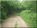
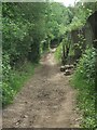
Public footpath along the eastern boundary of Broadlands, Bridgend (3)
A kissing gate and standard metal gate are situated on the public footpath a short distance north of the A48.
Image: © eswales
Taken: 8 Jun 2021
0.08 miles
2
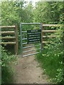
Gate at the southern end of a permissive path, Broadlands
This gate is a very short distance north of Bypass Road – the A48 - at the side of the public footpath which runs along the eastern edge of Broadlands in Bridgend. The permissive path which starts here is not shown on Ordnance Survey maps, but satellite photography online shows it running to Celestial Way, a nearby road (with a church) in the south of Broadlands.
Image: © eswales
Taken: 8 Jun 2021
0.09 miles
3
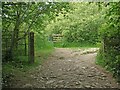
Gateway on public footpath by the south east corner of Broadlands, Bridgend
Situated immediately to the north of the A48 Bypass Road on the public footpath which runs along the eastern boundary of Broadlands. A waymarker on the left gatepost points along the public footpath. To the left of the path at the point where it turns a gate with a notice can be seen. This gate, which is situated at the southern end of a permissive path, is shown in Image The kissing gate seen next to the left gatepost presumably sees little use these days.
Image: © eswales
Taken: 8 Jun 2021
0.10 miles
4
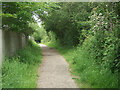
Public footpath along the eastern boundary of Broadlands, Bridgend (2)
The fence in the image marks the eastern edge of housing at Broadlands, a suburb of Bridgend. An area of ancient woodland lies on the other, east side of the path.
Image: © eswales
Taken: 8 Jun 2021
0.12 miles
5
Public footpath along the eastern boundary of Broadlands, Bridgend
A public footpath passes along the eastern boundary of Broadlands, a Bridgend suburb, over a distance of approximately a kilometre. As it does so it also passes along the edge of an area of ancient woodland to its east (in this image, to the left).
Image: © eswales
Taken: 8 Jun 2021
0.17 miles
6
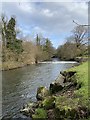
Ogmore River
Weir above the dipping bridge, Merthyr Mawr.
Image: © Alan Hughes
Taken: 1 Feb 2020
0.18 miles
7
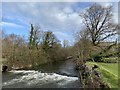
Ogmore River
A weir on the Ogmore River.
Image: © Alan Hughes
Taken: 1 Feb 2020
0.18 miles
8
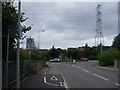
Roundabout and Pylon
Roundabout on B4622. Electricity lines, with pylon, running parallel at this point near Broadlands.
Image: © Colin Pyle
Taken: 6 Aug 2008
0.19 miles
9
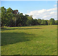
River meadow to the north of New Inn Bridge
Northward view of a meadow adjacent to the Ogmore River between New Inn Bridge and the A 48.
Image: © eswales
Taken: 18 May 2008
0.20 miles
10
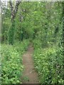
Permissive path in woodland by A48 underpass, Bridgend
A short stretch of a permissive path which walkers pass along when using an underpass beneath the A48 on the western outskirts of Bridgend. The southern entrance to the underpass lies just behind the camera.
Using the permissive path and underpass is an option available to those on the public footpath between Newbridge Fields and New Inn Bridge if they wish to avoid walking across the very busy A48.
Image: © eswales
Taken: 8 Jun 2021
0.21 miles