IMAGES TAKEN NEAR TO
Careg Llwyd, BRIDGEND, CF31 5BS
Introduction
This page details the photographs taken nearby to Careg Llwyd, CF31 5BS by members of the Geograph project.
The Geograph project started in 2005 with the aim of publishing, organising and preserving representative images for every square kilometre of Great Britain, Ireland and the Isle of Man.

There are currently over 7.5m images from over14,400 individuals and you can help contribute to the project by visiting https://www.geograph.org.uk
Image Map
Images are licensed for reuse under creativecommons.org/licenses/by-sa/2.0
Notes
- Clicking on the map will re-center to the selected point.
- The higher the marker number, the further away the image location is from the centre of the postcode.
Image Listing (20 Images Found)
Images are licensed for reuse under creativecommons.org/licenses/by-sa/2.0
Image
Details
Distance
1
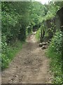
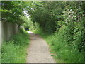
Public footpath along the eastern boundary of Broadlands, Bridgend
A public footpath passes along the eastern boundary of Broadlands, a Bridgend suburb, over a distance of approximately a kilometre. As it does so it also passes along the edge of an area of ancient woodland to its east (in this image, to the left).
Image: © eswales
Taken: 8 Jun 2021
0.06 miles
2
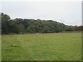
Open ground and ancient woodland in the south of Bridgend
The open area in the foreground lies between Newbridge Farm and the A48. Part of a faint path leading to an underpass beneath that road (situated behind the camera) can be seen running across the open ground.
The ancient woodland in the image covers the steep slope of Craig-y-Parcau. Nearer the camera are trees on the opposite, east side of the River Ogmore. The woodland at Craig-y-Parcau is classed as Ancient Semi-Natural Woodland. This means that broadleaf woodland consisting mainly of native trees and shrubs is believed to have existed there for over 400 years - https://naturalresources.wales/evidence-and-data/research-and-reports/ancient-woodland-inventory/?lang=en.
Image: © eswales
Taken: 8 Jun 2021
0.07 miles
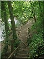
3
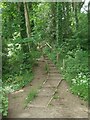
Steps at Craig-y-Parcau Local Nature Reserve, Bridgend
The more southerly of two sets of steps - approximately 300 metres apart - which descend to the side of the River Ogmore from the main path at the nature reserve.
Image: © eswales
Taken: 8 Jun 2021
0.09 miles
4
Public footpath towards Newbridge Fields
A public footpath from New Inn Bridge, Merthyr Mawr heads north-eastwards towards Newbridge Fields and the centre of Bridgend. Here, as over its entire course, the path runs close to the River Ogmore. It may be noted, however, that due to the presence of trees and other vegetation views of the river are limited from much of the path to the north of the A 48.
The sign seen in the image points back along a stretch of path towards Merthyr Mawr on which the walker passes through a small subway beneath the A 48, so avoiding a crossing of that busy road on foot, as sticking to the public footpath requires. This stretch of path rejoins the public footpath on the other (south) side of the A 48.
Image: © eswales
Taken: 2 Feb 2018
0.10 miles
5
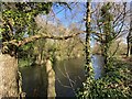
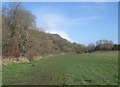
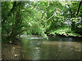
Ogmore River
View through riverside woodland near Newbridge fields.
Image: © Alan Hughes
Taken: 1 Feb 2020
0.10 miles
6
Public footpath along the eastern boundary of Broadlands, Bridgend (2)
The fence in the image marks the eastern edge of housing at Broadlands, a suburb of Bridgend. An area of ancient woodland lies on the other, east side of the path.
Image: © eswales
Taken: 8 Jun 2021
0.11 miles
7

Craig-y-Parcau Local Nature Reserve Trail
The other side of the Ogmore River from Newbridge Fields lies Craig-y-Parcau Local Nature Reserve which contains a number of walking trails through the deciduous woodland.
(Note that most are not suited to the mobility challenged being unsurfaced and including steep portions and steps in places.)
Image: © Steve Barnes
Taken: 28 Feb 2021
0.19 miles
8
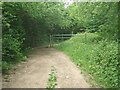
Public footpath along the eastern boundary of Broadlands, Bridgend (3)
A kissing gate and standard metal gate are situated on the public footpath a short distance north of the A48.
Image: © eswales
Taken: 8 Jun 2021
0.19 miles
9
Steps down to the River Ogmore at Craig-y-Parcau, Bridgend
A view from the more northerly of two sets of steps at Craig-y-Parcau Local Nature Reserve. These both descend to the side of the river from a path which runs relatively high up along the wooded slope on which the reserve is situated.
Image: © eswales
Taken: 8 Jun 2021
0.20 miles
10
The River Ogmore at Craig-y-Parcau Local Nature Reserve
A view upstream from the area beside the river seen in Image Newbridge Fields lie just beyond the trees on the other side of the river.
Image: © eswales
Taken: 8 Jun 2021
0.21 miles