IMAGES TAKEN NEAR TO
Chantal Avenue, BRIDGEND, CF31 4NN
Introduction
This page details the photographs taken nearby to Chantal Avenue, CF31 4NN by members of the Geograph project.
The Geograph project started in 2005 with the aim of publishing, organising and preserving representative images for every square kilometre of Great Britain, Ireland and the Isle of Man.

There are currently over 7.5m images from over14,400 individuals and you can help contribute to the project by visiting https://www.geograph.org.uk
Image Map
Images are licensed for reuse under creativecommons.org/licenses/by-sa/2.0
Notes
- Clicking on the map will re-center to the selected point.
- The higher the marker number, the further away the image location is from the centre of the postcode.
Image Listing (5 Images Found)
Images are licensed for reuse under creativecommons.org/licenses/by-sa/2.0
Image
Details
Distance
1

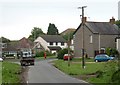
Near Penyfai
Near Penyfai, Tregwyneth East, a plaque on the verge near the houses
Image: © Colin Prosser
Taken: 4 Jul 2021
0.17 miles
2
Pen y fai
Looking East towards cottages at the T-junction
Image: © Chris Shaw
Taken: Unknown
0.18 miles
3
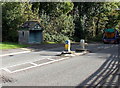
Pedestrian refuge and bus shelter, Pen-y-fai
Viewed across the A4063 Bridgend Road north of Bridgend.
Image: © Jaggery
Taken: 10 Oct 2014
0.24 miles
4
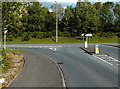
Junction in Pen-y-fai
Heol Ty'n-y-Garn ends at the A4063 Bridgend Road junction.
Left for Aberkenfig (½ mile) or right for the centre of Bridgend (2 miles).
Image: © Jaggery
Taken: 10 Oct 2014
0.24 miles
5
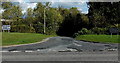
Rough road surface in Pen-y-fai
On an access road from the A4063 Bridgend Road to TSW Training.
Image: © Jaggery
Taken: 10 Oct 2014
0.24 miles