IMAGES TAKEN NEAR TO
Pen-y-Fai, BRIDGEND, CF31 4LP
Introduction
This page details the photographs taken nearby to CF31 4LP by members of the Geograph project.
The Geograph project started in 2005 with the aim of publishing, organising and preserving representative images for every square kilometre of Great Britain, Ireland and the Isle of Man.

There are currently over 7.5m images from over14,400 individuals and you can help contribute to the project by visiting https://www.geograph.org.uk
Image Map
Images are licensed for reuse under creativecommons.org/licenses/by-sa/2.0
Notes
- Clicking on the map will re-center to the selected point.
- The higher the marker number, the further away the image location is from the centre of the postcode.
Image Listing (102 Images Found)
Images are licensed for reuse under creativecommons.org/licenses/by-sa/2.0
Image
Details
Distance
1
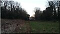
Glanrhyd to Tyn y Garn
Glanrhyd to Tyn y Garn, view of the houses in the lane, from across the fields, between Glanrhyd and Tyn y Garn
Image: © Colin Prosser
Taken: 28 Feb 2021
0.01 miles
3
Cycle route 885 towards the River Ogmore, Pen-y-cae
Looking along a part of National Cycle Network route 885. At the end of the road ahead,
the route follows a track on the east bank of the River Ogmore (Afon Ogwr in Welsh).
Image: © Jaggery
Taken: 10 Oct 2014
0.05 miles
4
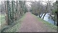
Glanrhyd
Glanrhyd, the footpath alongside the river Ogmore, and footpath which leads into the lanes
Image: © Colin Prosser
Taken: 7 Mar 2021
0.06 miles
5
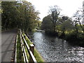
Downstream along the Ogmore, Pen-y-cae
The River Ogmore (Afon Ogwr in Welsh) is here about 8km from its mouth between
the Merthyr Mawr sand dunes and the descriptively-named seaside village of Ogmore-by-Sea.
Image: © Jaggery
Taken: 10 Oct 2014
0.06 miles
6
Glanrhyd
Riverside walk from Glanrhyd to Tyn y Garn
Image: © Colin Prosser
Taken: 28 Feb 2021
0.07 miles
7
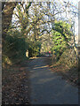
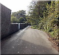
National Cycle Route 885 between Glanrhyd and Pen-y-cae
Northward view on a stretch of the cycle route where you pass along a private road.
Image: © eswales
Taken: 16 Jan 2023
0.07 miles
8
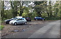
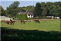
Riverside car park, Pen-y-cae
Between a minor road and the River Ogmore.
Image: © Jaggery
Taken: 10 Oct 2014
0.08 miles
9

Glanrhyd
Glanrhyd, view up river of the Ogmore river, between Glanrhyd hospital and the lodge near the S bends just below Tyrisha
Image: © Colin Prosser
Taken: 7 Mar 2021
0.08 miles
10

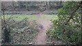
Glanrhyd
Glanrhyd to Tyn y Garn, riverside footpath, fallen trees from storm damage
Image: © Colin Prosser
Taken: 27 Feb 2022
0.08 miles