IMAGES TAKEN NEAR TO
Elm Crescent, BRIDGEND, CF31 4EP
Introduction
This page details the photographs taken nearby to Elm Crescent, CF31 4EP by members of the Geograph project.
The Geograph project started in 2005 with the aim of publishing, organising and preserving representative images for every square kilometre of Great Britain, Ireland and the Isle of Man.

There are currently over 7.5m images from over14,400 individuals and you can help contribute to the project by visiting https://www.geograph.org.uk
Image Map
Images are licensed for reuse under creativecommons.org/licenses/by-sa/2.0
Notes
- Clicking on the map will re-center to the selected point.
- The higher the marker number, the further away the image location is from the centre of the postcode.
Image Listing (73 Images Found)
Images are licensed for reuse under creativecommons.org/licenses/by-sa/2.0
Image
Details
Distance
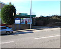
1
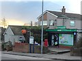
Bryntirion Post Office
Post Office and general store, Bryntirion.
Image: © Alan Hughes
Taken: 10 Feb 2016
0.05 miles
2
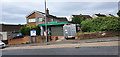
Bryntirion Post Office
Is also a small convenience store so even open on Sunday
Image: © Steve Barnes
Taken: 16 Jun 2019
0.05 miles
3
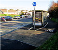
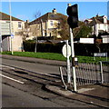
Cycle path past a Bryntirion Hill bus shelter in Bridgend
According to the blue sign, cyclists should go on the right side of the bus shelter,
walkers on the left (road) side. I wonder how many walkers do so...
Image: © Jaggery
Taken: 24 Dec 2014
0.05 miles
4
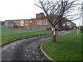
Bryntirion Infant School, Bridgend
Viewed from the Bryngolau entrance gate http://www.geograph.org.uk/photo/4293219 looking towards the brick building dating from 1956. There are c140 children enrolled, either in the nursery unit (ages 3-4) or one of four infant classes (ages 4-7).
Image: © Jaggery
Taken: 24 Dec 2014
0.05 miles
5
Bryntirion Infants School
Bryntirion Infants School, Bridgend.
Image: © Alan Hughes
Taken: 10 Feb 2016
0.05 miles
6
Bryntirion Post Office, Bridgend
In a Londis shop on the west side of Bright Hill (Bryngolau in Welsh).
Image: © Jaggery
Taken: 24 Dec 2014
0.05 miles
7
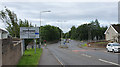
Junction of A473 & B4622
Sometimes suffers from long queues (at the end of school day especially).
Image: © Steve Barnes
Taken: 16 Jun 2019
0.06 miles
8
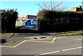
Bryngolau entrance gate to Bryntirion Infant School, Bridgend
The gate on the west side of Bryngolau (Bright Hill in English) is at an entrance to this http://www.geograph.org.uk/photo/4293209 school.
Image: © Jaggery
Taken: 24 Dec 2014
0.06 miles
9
Bilingual street name sign in Bridgend
The sign on the right shows Bryngolau (in Welsh), and Bright Hill.
The names are equivalents, which is not always the case, such as here http://www.geograph.org.uk/photo/4191428 in Caerphilly.
Image: © Jaggery
Taken: 24 Dec 2014
0.07 miles
10
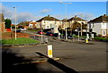
Major crossroads in the west of Bridgend
The A473 Bryntirion Hill (left to right, west to east) is intersected by
Bryngolau (Bright Hill) to the north (ahead) and the B4622 on the camera side.
Image: © Jaggery
Taken: 24 Dec 2014
0.07 miles