IMAGES TAKEN NEAR TO
Ton Glas, BRIDGEND, CF31 4EH
Introduction
This page details the photographs taken nearby to Ton Glas, CF31 4EH by members of the Geograph project.
The Geograph project started in 2005 with the aim of publishing, organising and preserving representative images for every square kilometre of Great Britain, Ireland and the Isle of Man.

There are currently over 7.5m images from over14,400 individuals and you can help contribute to the project by visiting https://www.geograph.org.uk
Image Map
Images are licensed for reuse under creativecommons.org/licenses/by-sa/2.0
Notes
- Clicking on the map will re-center to the selected point.
- The higher the marker number, the further away the image location is from the centre of the postcode.
Image Listing (104 Images Found)
Images are licensed for reuse under creativecommons.org/licenses/by-sa/2.0
Image
Details
Distance
1
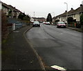
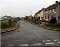
Greenmeadow/Ton Glas, Bryntirion, Bridgend
Looking east along Greenmeadow (Ton Glas in Welsh) from the corner of Broad Oak Way.
Image: © Jaggery
Taken: 16 Nov 2018
0.01 miles
2
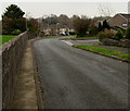
Towards a bend in Mount Pleasant, Bryntirion, Bridgend
On the descent of Mount Pleasant from Llangewydd Road to Broad Oak Way.
The broken white lines are at the junction with the western arm of Mount Pleasant. https://www.geograph.org.uk/photo/5989025
Image: © Jaggery
Taken: 16 Nov 2018
0.06 miles
3
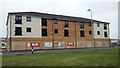
Bryntirion Bridgend
New housing complex near completion, on former Ogmore Constituency Labour Club site
Image: © Colin Prosser
Taken: 17 Aug 2018
0.06 miles
4
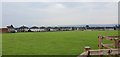
Bryntirion Playing Field
Just opposite the Football Ground
Image: © Steve Barnes
Taken: 23 Jun 2019
0.08 miles
5
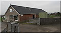
Welsh Medium Playgroup name sign, Bryntirion
The name banner for the Welsh Medium Playgroup Cylch Meithrin Gwdihŵ is on the wall on the south side of Bryntirion & Laleston Community Centre in Bryntirion, a Bridgend suburb. The playgroup which is conducted via the medium of the Welsh language is for children aged 2,3 or 4.
Image: © Jaggery
Taken: 16 Nov 2018
0.09 miles
6
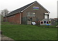
Bryntirion & Laleston Community Centre
Set back from the road named Mount Pleasant in Bryntirion.
Image: © Jaggery
Taken: 16 Nov 2018
0.10 miles
7
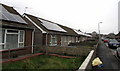
Rooftop solar panels, Elm Crescent, Bryntirion
Optimally located on south facing roofs on bungalows on the north side of Elm Crescent.
Image: © Jaggery
Taken: 16 Nov 2018
0.10 miles
8
Elm Crescent bungalows, Bryntirion
Strictly, a bungalow is a lightly-built house, with a veranda and one storey.
In current UK usage it is a convenient word for any one-storey dwelling.
Image: © Jaggery
Taken: 24 Dec 2014
0.10 miles
9
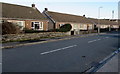
Northern end of Mount Pleasant, Bryntirion, Bridgend
Looking south from Llangewydd Road. Houses on the right,
Bryntirion & Laleston Community Centre http://www.geograph.org.uk/photo/5977228 on the left.
Image: © Jaggery
Taken: 16 Nov 2018
0.10 miles
10
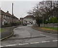
Western arm of Mount Pleasant, Bryntirion, Bridgend
The dead-end western arm of Mount Pleasant viewed from the main north-south part of Mount Pleasant.
Image: © Jaggery
Taken: 16 Nov 2018
0.10 miles