IMAGES TAKEN NEAR TO
Heol-y-Ffin, BRIDGEND, CF31 4DN
Introduction
This page details the photographs taken nearby to Heol-y-Ffin, CF31 4DN by members of the Geograph project.
The Geograph project started in 2005 with the aim of publishing, organising and preserving representative images for every square kilometre of Great Britain, Ireland and the Isle of Man.

There are currently over 7.5m images from over14,400 individuals and you can help contribute to the project by visiting https://www.geograph.org.uk
Image Map
Images are licensed for reuse under creativecommons.org/licenses/by-sa/2.0
Notes
- Clicking on the map will re-center to the selected point.
- The higher the marker number, the further away the image location is from the centre of the postcode.
Image Listing (52 Images Found)
Images are licensed for reuse under creativecommons.org/licenses/by-sa/2.0
Image
Details
Distance
1
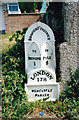
Old Milestone by the A473, Bryntirion Hill, Bridgend parish
Glamorgan Gothic by the A473 (was A48), in parish of Bridgend (Bridgend County Borough District), Bryntirion Hill, 100m East of junction with the B4622, against wall.
Inscription reads:-
: TO / BRIDGEND / 1 : : BRIDGEND DISTRICT : : TO / PYLE / 5 : : LONDON / 178 : : NEWCASTLE PARISH :
Surveyed
Milestone Society National ID: GLA_178BEPY01
Image: © Milestone Society
Taken: Unknown
0.05 miles
2
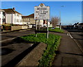
Welcome to the town of Bridgend
Alongside the A473 Bryntirion Hill at the western edge of the town of Bridgend.
With a population of c40,000 Bridgend is the largest town in Bridgend County Borough.
It has about twice the population of the two next biggest, Maesteg and Porthcawl.
Image: © Jaggery
Taken: 24 Dec 2014
0.07 miles
3
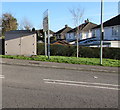
Bryngolau electricity substation, Bridgend
The identifier on the Western Power Distribution electricity substation on
the east side of Bryngolau (Bright Hill in English) is BRYNGOLAU S/S BRIDGEND 564016.
Image: © Jaggery
Taken: 24 Dec 2014
0.09 miles
4
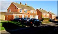
Beechwood Avenue, Bridgend
Viewed from the corner of Bryngolau/Bright Hill.
Image: © Jaggery
Taken: 24 Dec 2014
0.09 miles
5
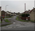
Beechwood Avenue, Bridgend
From Heol-y-frenhines along Beechwood Avenue towards Bryngolau (Bright Hill in English).
The walker is on the corner of Philip Avenue.
Image: © Jaggery
Taken: 16 Nov 2018
0.09 miles
6
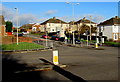
Major crossroads in the west of Bridgend
The A473 Bryntirion Hill (left to right, west to east) is intersected by
Bryngolau (Bright Hill) to the north (ahead) and the B4622 on the camera side.
Image: © Jaggery
Taken: 24 Dec 2014
0.10 miles
7
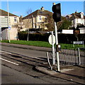
Bilingual street name sign in Bridgend
The sign on the right shows Bryngolau (in Welsh), and Bright Hill.
The names are equivalents, which is not always the case, such as here http://www.geograph.org.uk/photo/4191428 in Caerphilly.
Image: © Jaggery
Taken: 24 Dec 2014
0.10 miles
8
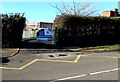
Bryngolau entrance gate to Bryntirion Infant School, Bridgend
The gate on the west side of Bryngolau (Bright Hill in English) is at an entrance to this http://www.geograph.org.uk/photo/4293209 school.
Image: © Jaggery
Taken: 24 Dec 2014
0.10 miles
9
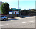
Bryntirion Post Office, Bridgend
In a Londis shop on the west side of Bright Hill (Bryngolau in Welsh).
Image: © Jaggery
Taken: 24 Dec 2014
0.10 miles
10
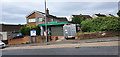
Bryntirion Post Office
Is also a small convenience store so even open on Sunday
Image: © Steve Barnes
Taken: 16 Jun 2019
0.11 miles