IMAGES TAKEN NEAR TO
St. Nicholas Road, BRIDGEND, CF31 1RT
Introduction
This page details the photographs taken nearby to St. Nicholas Road, CF31 1RT by members of the Geograph project.
The Geograph project started in 2005 with the aim of publishing, organising and preserving representative images for every square kilometre of Great Britain, Ireland and the Isle of Man.

There are currently over 7.5m images from over14,400 individuals and you can help contribute to the project by visiting https://www.geograph.org.uk
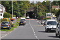
Image Map
Images are licensed for reuse under creativecommons.org/licenses/by-sa/2.0
Notes
- Clicking on the map will re-center to the selected point.
- The higher the marker number, the further away the image location is from the centre of the postcode.
Image Listing (43 Images Found)
Images are licensed for reuse under creativecommons.org/licenses/by-sa/2.0
Image
Details
Distance

2
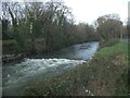
The River Ogmore at Wildmill, Bridgend
The river is seen flowing over a weir on a stretch adjacent to St Christopher’s Road at the western edge of Bridgend.
Image: © eswales
Taken: 1 Jan 2023
0.04 miles
4
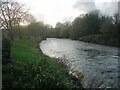
The River Ogmore at the western edge of Bridgend
A view downstream from a spot beside National Cycle Route 885 just as it reaches the fringes of the town from the north. The stretch of the river seen in the image lies immediately downstream of the one seen in Image
Image: © eswales
Taken: 1 Nov 2022
0.07 miles
5
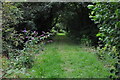
Bridgend : Grassy Path
A grassy path alongside the River Ogmore which doesn't lead anywhere.
Image: © Lewis Clarke
Taken: 24 Aug 2014
0.12 miles
6
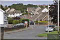
Bridgend : St Andrew's Road
Looking up St Andrew's Road in Bridgend.
Image: © Lewis Clarke
Taken: 24 Aug 2014
0.12 miles
7
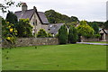
Bridgend : Angelton Villa
Looking towards a house on the Bridgend outskirts.
Image: © Lewis Clarke
Taken: 24 Aug 2014
0.13 miles
8
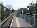
Wildmill Railway Station : the view north
Looking north beyond the only platform on Wildmill railway station. The next station north is Sarn, on the route to Maesteg. The route is operated by Arriva Trains Wales (ATW) as part of the Valley Lines network.
See http://www.geograph.org.uk/photo/1691278 for a description of the 'Adopt a Station' scheme.
Image: © Jaggery
Taken: 26 Oct 2009
0.13 miles
9
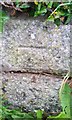
Ordnance Survey Cut Mark
This OS cut mark can be found on wall north side of the road. It marks a point 25.884m above mean sea level.
Image: © Adrian Dust
Taken: 26 May 2018
0.13 miles
10
Bridgend : Wild Mill Lane
Wild Mill Lane heading through the Bridgend suburbs.
Image: © Lewis Clarke
Taken: 24 Aug 2014
0.13 miles