IMAGES TAKEN NEAR TO
St. Patricks Drive, BRIDGEND, CF31 1RP
Introduction
This page details the photographs taken nearby to St. Patricks Drive, CF31 1RP by members of the Geograph project.
The Geograph project started in 2005 with the aim of publishing, organising and preserving representative images for every square kilometre of Great Britain, Ireland and the Isle of Man.

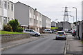
There are currently over 7.5m images from over14,400 individuals and you can help contribute to the project by visiting https://www.geograph.org.uk
Image Map
Images are licensed for reuse under creativecommons.org/licenses/by-sa/2.0
Notes
- Clicking on the map will re-center to the selected point.
- The higher the marker number, the further away the image location is from the centre of the postcode.
Image Listing (48 Images Found)
Images are licensed for reuse under creativecommons.org/licenses/by-sa/2.0
Image
Details
Distance
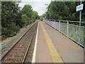
1
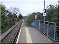
Wildmill Railway Station : the view north
Looking north beyond the only platform on Wildmill railway station. The next station north is Sarn, on the route to Maesteg. The route is operated by Arriva Trains Wales (ATW) as part of the Valley Lines network.
See http://www.geograph.org.uk/photo/1691278 for a description of the 'Adopt a Station' scheme.
Image: © Jaggery
Taken: 26 Oct 2009
0.04 miles
2
Litchard Terrace approaching wooded area
As it draws near to Wild Mill, Litchard Terrace passes through a wooded area.
Image: © Jaggery
Taken: 26 Oct 2009
0.08 miles
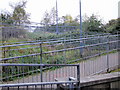
3
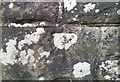
Ordnance Survey Cut Mark
This OS cut mark can be found on the north buttress of the railway bridge. It marks a point 32.239m above mean sea level.
Image: © Adrian Dust
Taken: 26 May 2018
0.08 miles
4
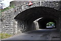
Bridgend : Wild Mill Lane
Looking under the railway bridges at Wild Mill Lane.
Image: © Lewis Clarke
Taken: 24 Aug 2014
0.08 miles
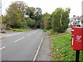
5
Bridgend : Maes Y Felin
Looking along a residential road in the Wild Mill area of Bridgend.
Image: © Lewis Clarke
Taken: 24 Aug 2014
0.09 miles
6
Zigzag entrance route to Wildmill station
A series of gently-inclined ramps provided a wheelchair-user friendly (if rather long) entrance into Wildmill station.
Railway signs show Wildmill, whereas street name signs in the area show Wild Mill.
See http://www.geograph.org.uk/photo/1691278 for a description of the 'Adopt a Station' scheme.
Image: © Jaggery
Taken: 26 Oct 2009
0.10 miles
7
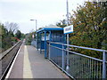
Shelter, Wildmill railway station
The only passenger facility on the unstaffed single platform Wildmill station is a small shelter, located next to the entrance/exit path.
A sign attached to the timetable information board outside the station states that Wildmill railway station was adopted by Mark Williams under the Arriva Trains Wales 'Adopt a Station' Initiative on October 5th 2006.
The 'Adopt a Station' scheme aims to help improve Arriva Trains Wales (ATW) links with local communities and customers living near unstaffed railway stations.
ATW want to keep their unstaffed stations clean and pleasant, so the scheme is designed to encourage regular feedback about the facilities available to help them ensure they meet the high standards expected by their customers.
ATW seek volunteers interested in the welfare of their local railway station. ATW refer to them as 'station adopters', with the task of reporting on matters such as litter, graffiti, vandalism, lighting, information help points and timetable information.
As an adopter, there is no financial commitment. ATW just require adopters to fill in regular survey forms for the local Station Manager describing the local station facilities. Other adoption activity could include improving the appearance of the station with extra touches such as floral displays, landscaping or artwork where practicable.
In return, adopters receive £75 of travel vouchers for use on any part of the National Rail Network.
Image: © Jaggery
Taken: 26 Oct 2009
0.10 miles
8
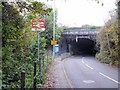
Wildmill railway bridge, Bridgend
Litchard Terrace nears its end at the bridge carrying the single-track railway.
Beyond the bridge, the road is Wild Mill Lane.
The entrance to Wildmill station is on the left. Railway signs show Wildmill, whereas street signs in the area show Wild Mill.
Image: © Jaggery
Taken: 26 Oct 2009
0.10 miles
9
Wildmill railway station, Bridgend
Opened in 1992 by British Rail on the line from Bridgend to Maesteg, although the original Llynvi & Ogmore Railway line ran further north, to Cymmer.
View north towards Sarn and Maesteg.
Image: © Nigel Thompson
Taken: 16 Aug 2014
0.10 miles
10
Bridgend : Wild Mill Lane
Wild Mill Lane passes underneath the railway station on the bridge.
Image: © Lewis Clarke
Taken: 24 Aug 2014
0.10 miles