IMAGES TAKEN NEAR TO
Penylan, BRIDGEND, CF31 1QW
Introduction
This page details the photographs taken nearby to Penylan, CF31 1QW by members of the Geograph project.
The Geograph project started in 2005 with the aim of publishing, organising and preserving representative images for every square kilometre of Great Britain, Ireland and the Isle of Man.

There are currently over 7.5m images from over14,400 individuals and you can help contribute to the project by visiting https://www.geograph.org.uk
Image Map
Images are licensed for reuse under creativecommons.org/licenses/by-sa/2.0
Notes
- Clicking on the map will re-center to the selected point.
- The higher the marker number, the further away the image location is from the centre of the postcode.
Image Listing (6 Images Found)
Images are licensed for reuse under creativecommons.org/licenses/by-sa/2.0
Image
Details
Distance
1

Ordnance Survey Cut Mark
This OS cut mark can be found on the wall south of the entrance to The Parc. It marks a point 65.536m above mean sea level.
Image: © Adrian Dust
Taken: 26 May 2018
0.13 miles
2

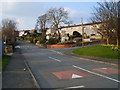
Bridgend : Coity Road B4181
Looking along Coity Road as it heads into Bridgend.
Image: © Lewis Clarke
Taken: 24 Aug 2014
0.13 miles


6
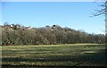
Woodland below Litchard
Viewed across a river meadow from Route 885 of the National Cycle Network, part of a strip of woodland which runs along the bottom and lower slopes of a hillside nearly a kilometre long. The more northerly parts of Litchard in Bridgend lie at the top of the hillside, along with an area of open ground to the north of them.
Most, if not all, of that part of the strip of woodland which is seen in the photo is classed as Ancient Semi-Natural Woodland in the Ancient Woodland Inventory for Wales. Other parts, out of picture to the north, however, do not qualify as ancient woodland.
Image: © eswales
Taken: 16 Jan 2023
0.25 miles