IMAGES TAKEN NEAR TO
Portmanmoor Road, CARDIFF, CF24 5FX
Introduction
This page details the photographs taken nearby to Portmanmoor Road, CF24 5FX by members of the Geograph project.
The Geograph project started in 2005 with the aim of publishing, organising and preserving representative images for every square kilometre of Great Britain, Ireland and the Isle of Man.

There are currently over 7.5m images from over14,400 individuals and you can help contribute to the project by visiting https://www.geograph.org.uk
Image Map (Loading...)


Getting Data...Please wait
Leaflet Map data © OpenStreetMap
Images are licensed for reuse under creativecommons.org/licenses/by-sa/2.0
Notes
- Clicking on the map will re-center to the selected point.
- The higher the marker number, the further away the image location is from the centre of the postcode.
Image Listing (39 Images Found)
Images are licensed for reuse under creativecommons.org/licenses/by-sa/2.0
Image
Details
Distance
4
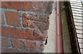
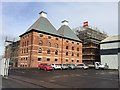
Ordnance Survey Cut Mark
This OS cut mark can be found on the west angle of The Maltings. It marks a point 8.950m above mean sea level.
Image: © Adrian Dust
Taken: 12 Oct 2017
0.11 miles
5
East Moors
Construction work on progress on the East Moors Industrial Estate.
Image: © Alan Hughes
Taken: 27 Feb 2017
0.11 miles
7
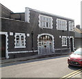
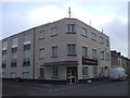
Eastmoors Neighbourhood Learning Centre, Cardiff
Located on Sanquahar Street.
Image: © Jaggery
Taken: 3 Sep 2010
0.14 miles
8
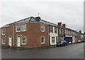
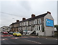
36 Carlisle Street
At the end of a row of pre-war houses, modernised flats now occupy the site of Ollin & Whitehurst, Greengrocers, in Carlisle Street, Splott.
Image: © Alan Hughes
Taken: 23 Dec 2016
0.15 miles
9
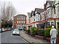
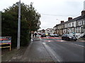
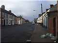
Farmville Road, Splott
Splott previously known as Splottlands, was once owned by the Bishop of Llandaff. Much of the housing in Splott is terraced.
Image: © Linda Bailey
Taken: 12 Feb 2006
0.15 miles
10
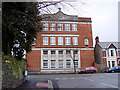
Splott University Settlement, Courteney Road
The Splott University Settlement (SUS) was founded in 1901 Portmanmoor Road, to promote education and recreation for the people of the district, moving in 1906 to the building on Walker/Courtenay Road. It is not connected to the University of Cardiff.
Note: That section of Walker Road between Splott Road and Moorland Road, was
renamed in 1915/16 to Courtenay Road after the second Lord Tredegar Courtenay
Morgan.
Shortly after the First World War, the Splott University Settlement building
became St Illtyd's College (1923-1964), a Grammar School for Catholic Boys in
Wales. After the Second World War the school moved to new premises at Quarry Hill, Rumney.
Image: © Linda Bailey
Taken: 12 Feb 2006
0.15 miles