IMAGES TAKEN NEAR TO
Horwood Close, CARDIFF, CF24 2LW
Introduction
This page details the photographs taken nearby to Horwood Close, CF24 2LW by members of the Geograph project.
The Geograph project started in 2005 with the aim of publishing, organising and preserving representative images for every square kilometre of Great Britain, Ireland and the Isle of Man.

There are currently over 7.5m images from over14,400 individuals and you can help contribute to the project by visiting https://www.geograph.org.uk
Image Map
Images are licensed for reuse under creativecommons.org/licenses/by-sa/2.0
Notes
- Clicking on the map will re-center to the selected point.
- The higher the marker number, the further away the image location is from the centre of the postcode.
Image Listing (171 Images Found)
Images are licensed for reuse under creativecommons.org/licenses/by-sa/2.0
Image
Details
Distance
1
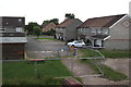
Horwood Close, Cardiff
This part of Horwood Close is below Beresford Road.
Image: © Jaggery
Taken: 16 Jun 2017
0.02 miles
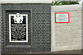
2
Horwood Close houses, Splott, Cardiff
From the corner of Vale Road. A nearby blue plaque http://www.geograph.org.uk/photo/5433111 records some former occupiers of this area.
Image: © Jaggery
Taken: 16 Jun 2017
0.03 miles
3
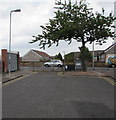
Northeast end of Railway Street, Splott, Cardiff
Metal railings, concrete posts and a tree prevent the passage of motor vehicles.
Double yellow lines indicate no parking at any time.
Image: © Jaggery
Taken: 16 Jun 2017
0.03 miles
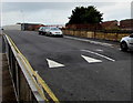
4
Beresford Road speed bump, Cardiff
Painted white triangles draw attention to the Beresford Road
speed bump opposite railings at the NE end of Railway Street.
Image: © Jaggery
Taken: 16 Jun 2017
0.03 miles
5
Beresford Road speed bump, Cardiff
Painted white triangles draw attention to the Beresford Road speed bump
on the ascent towards the bridge over the South Wales main line railway.
Image: © Jaggery
Taken: 16 Jun 2017
0.03 miles
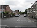
6
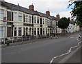
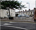
Moorland Road houses, Splott, Cardiff
These houses on the west side of Moorland Road are between a humped zebra crossing
warning sign and a zebra crossing on a hump. Viewed from the corner of Vale Road.
Image: © Jaggery
Taken: 16 Jun 2017
0.04 miles
7
Zigzag white lines on Moorland Road, Cardiff
On the approach to this http://www.geograph.org.uk/photo/5434454 zebra crossing on a hump.
A bilingual (English/Welsh) warning sign is on the left.
Image: © Jaggery
Taken: 16 Jun 2017
0.04 miles
8
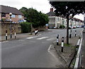
Zebra crossing on a hump, Moorland Road, Cardiff
The crossing is near Vale Road, next left ahead.
Image: © Jaggery
Taken: 16 Jun 2017
0.04 miles
9
Plaque and notice, Beresford Road bridge
There are two copies of the plaque celebrating the 1908 bridge, which no longer exists - see Image and Image - at either end of the new bridge. This is at the southeastern end, alongside the red notice about contacting the authorities if witnessing a collision with the structure, which is number SWM2 168m 53c. The plaque is shown more closely in Image
Image: © Derek Harper
Taken: 16 Jun 2018
0.05 miles
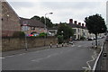
10
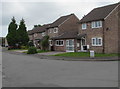
Vale Road, Splott, Cardiff
From Moorland Road, Vale Road leads to Horwood Close and Dowlais Court.
Image: © Jaggery
Taken: 16 Jun 2017
0.05 miles