IMAGES TAKEN NEAR TO
Moorland Road, CARDIFF, CF24 2LQ
Introduction
This page details the photographs taken nearby to Moorland Road, CF24 2LQ by members of the Geograph project.
The Geograph project started in 2005 with the aim of publishing, organising and preserving representative images for every square kilometre of Great Britain, Ireland and the Isle of Man.

There are currently over 7.5m images from over14,400 individuals and you can help contribute to the project by visiting https://www.geograph.org.uk
Image Map
Images are licensed for reuse under creativecommons.org/licenses/by-sa/2.0
Notes
- Clicking on the map will re-center to the selected point.
- The higher the marker number, the further away the image location is from the centre of the postcode.
Image Listing (75 Images Found)
Images are licensed for reuse under creativecommons.org/licenses/by-sa/2.0
Image
Details
Distance
1
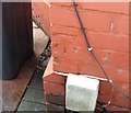
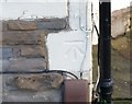
Ordnance Survey Cut Mark
This OS cut mark can be found on No184 Moorland Road. It marks a point 8.172m above mean sea level.
Image: © Adrian Dust
Taken: 16 Mar 2018
0.05 miles
2

Splott Clinic, Cardiff
Located on South Park Road.
Image: © Jaggery
Taken: 3 Sep 2010
0.07 miles
3
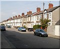
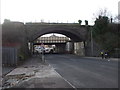
Moorland Road north of South Park Road, Cardiff
Houses on the east side of Moorland Road. The view is looking north from South Park Road.
Image: © Jaggery
Taken: 3 Sep 2010
0.07 miles
4
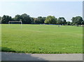
Splott Park, Cardiff
The view across football pitches from Muirton Road, at the SE edge of the park.
Image: © Jaggery
Taken: 3 Sep 2010
0.08 miles

6

St. Saviours Vicarage formerly Lower Splott Farm
St. Saviours the Grade II listed vicarage, formerly Lower Splott Farm
The early history of Splott is given in the Cardiff Records. Splott was anciently held by the Bawdrips of Penmark. It consisted mainly of two farms, called the Upper and Lower Splott, situated between Roath Village and the sea.
1440 - the Splott is mentioned as bounding certain lands of Isabel le Despenser, Countess of Worcester and Warwick.
1596 - William Bawdrippe of Penmark built a fair house at the Splott and made it his chief residence.
1626 - William Bawdrip of Splott was Member of Parliament for Cardiff. He sold Penmark and Splott to Sir Edward Lewis of the Van.
1638 - Sir Edward Lewis of the Van died.
1740 - the Llandaff Survey of this year mentions a chief rent of four shillings as payable in respect of Splott Farm in Roath.
To the east of Adamsdown and Portmanmoor Lower Splott is nearer to the Severn estuary. The old dairy was contained on the ground floor of the building's extension to the right.
Image: © Chris Moorman
Taken: 27 Dec 2007
0.08 miles
7

Lower Splott Farm
Formerly St. Saviours a Grade II listed building was before that era Lower Splott Farm
The early history of Splott is given in the Cardiff Records. Splott was anciently held by the Bawdrips of Penmark. It consisted mainly of two farms, called the Upper and Lower Splott, situated between Roath Village and the sea.
1440 - the Splott is mentioned as bounding certain lands of Isabel le Despenser, Countess of Worcester and Warwick.
1596 - William Bawdrippe of Penmark built a fair house at the Splott and made it his chief residence.
1626 - William Bawdrip of Splott was Member of Parliament for Cardiff. He sold Penmark and Splott to Sir Edward Lewis of the Van.
1638 - Sir Edward Lewis of the Van died.
1740 - the Llandaff Survey of this year mentions a chief rent of four shillings as payable in respect of Splott Farm in Roath.
Image: © Chris Moorman
Taken: 26 Dec 2007
0.09 miles
8
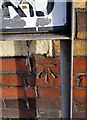
Ordnance Survey Cut Mark
This OS cut mark can be found on No139 South Park Road. It marks a point 8.476m above mean sea level.
Image: © Adrian Dust
Taken: 16 Mar 2018
0.09 miles
10
Ordnance Survey Cut Mark
This OS cut mark can be found on No118 Moorland Road. It marks a point 10.004m above mean sea level.
Image: © Adrian Dust
Taken: 16 Mar 2018
0.11 miles