IMAGES TAKEN NEAR TO
Aberystwyth Street, CARDIFF, CF24 2EW
Introduction
This page details the photographs taken nearby to Aberystwyth Street, CF24 2EW by members of the Geograph project.
The Geograph project started in 2005 with the aim of publishing, organising and preserving representative images for every square kilometre of Great Britain, Ireland and the Isle of Man.

There are currently over 7.5m images from over14,400 individuals and you can help contribute to the project by visiting https://www.geograph.org.uk
Image Map
Images are licensed for reuse under creativecommons.org/licenses/by-sa/2.0
Notes
- Clicking on the map will re-center to the selected point.
- The higher the marker number, the further away the image location is from the centre of the postcode.
Image Listing (35 Images Found)
Images are licensed for reuse under creativecommons.org/licenses/by-sa/2.0
Image
Details
Distance
10
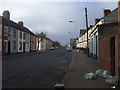
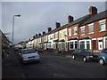
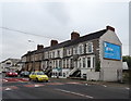
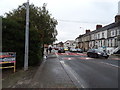
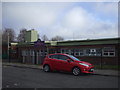
Farmville Road, Splott
Splott previously known as Splottlands, was once owned by the Bishop of Llandaff. Much of the housing in Splott is terraced.
Image: © Linda Bailey
Taken: 12 Feb 2006
0.14 miles