IMAGES TAKEN NEAR TO
Gold Street, CARDIFF, CF24 0LF
Introduction
This page details the photographs taken nearby to Gold Street, CF24 0LF by members of the Geograph project.
The Geograph project started in 2005 with the aim of publishing, organising and preserving representative images for every square kilometre of Great Britain, Ireland and the Isle of Man.

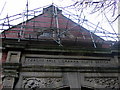
There are currently over 7.5m images from over14,400 individuals and you can help contribute to the project by visiting https://www.geograph.org.uk
Image Map
Images are licensed for reuse under creativecommons.org/licenses/by-sa/2.0
Notes
- Clicking on the map will re-center to the selected point.
- The higher the marker number, the further away the image location is from the centre of the postcode.
Image Listing (91 Images Found)
Images are licensed for reuse under creativecommons.org/licenses/by-sa/2.0
Image
Details
Distance
1
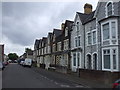
Gold St, Cardiff
As befits its name, the houses in this street are larger (3 storey) than those in the nearby streets, called after baser metals.
Image: © John Lord
Taken: 8 May 2010
0.01 miles
2
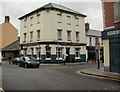
The Clifton, Cardiff
Pub dating from the late nineteenth century, on the corner of Clifton Street and Broadway, viewed from Four Elms Road.
Whatever may be the use, if any, of the top floor of the building, it doesn't need windows.
Image: © Jaggery
Taken: 15 Jul 2010
0.01 miles
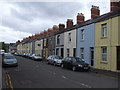
3
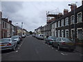
Silver St, Cardiff
All the streets off Clifton St, to the west, are called after metals.
Image: © John Lord
Taken: 8 May 2010
0.05 miles
4
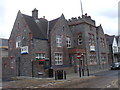
Police station, Clifton St, Cardiff
At the junction with Gold St.
Image: © John Lord
Taken: 8 May 2010
0.05 miles
5
Library facade with literary cherub
Image: © Natasha Ceridwen de Chroustchoff
Taken: 29 Nov 2007
0.06 miles
6
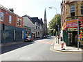
Four Elms Road, Cardiff
The view from the corner of Clifton Street, looking towards the spire of Trinity Methodist Church.
Image: © Jaggery
Taken: 9 Sep 2009
0.06 miles
7
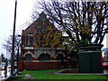
Roath public library
On the apex of Newport Road and Four Elms Road. Built at the end of the C19 when churches, schools and other public facilities sprang up to meet the needs of the expanding population of this part of Cardiff.
Image: © Natasha Ceridwen de Chroustchoff
Taken: 29 Nov 2007
0.06 miles
8
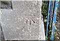
Ordnance Survey Cut Mark
This OS cut mark can be found on the Methodist Church, Four Elms Road. It marks a point 12.954m above mean sea level.
Image: © Adrian Dust
Taken: 12 Oct 2017
0.06 miles
9
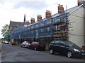
Terraced houses being refurbished, Metal St, Cardiff.
Image: © John Lord
Taken: 8 May 2010
0.07 miles
10
Orbit St, Cardiff
The streets around all have names connected with astronomy.
Image: © John Lord
Taken: 8 May 2010
0.07 miles