IMAGES TAKEN NEAR TO
Ravenscourt Close, CARDIFF, CF23 9DJ
Introduction
This page details the photographs taken nearby to Ravenscourt Close, CF23 9DJ by members of the Geograph project.
The Geograph project started in 2005 with the aim of publishing, organising and preserving representative images for every square kilometre of Great Britain, Ireland and the Isle of Man.

There are currently over 7.5m images from over14,400 individuals and you can help contribute to the project by visiting https://www.geograph.org.uk
Image Map
Images are licensed for reuse under creativecommons.org/licenses/by-sa/2.0
Notes
- Clicking on the map will re-center to the selected point.
- The higher the marker number, the further away the image location is from the centre of the postcode.
Image Listing (14 Images Found)
Images are licensed for reuse under creativecommons.org/licenses/by-sa/2.0
Image
Details
Distance
1
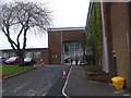
The Howardian Centre, Cardiff
Formerly Howardian High School. The school's name derived from its original site, Howard Gardens, near the city centre.
Image: © John Lord
Taken: 23 Feb 2012
0.15 miles
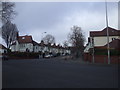
2

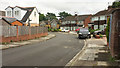
Southcourt Road, Penylan, Cardiff
Houses on the east side of the road, viewed from the corner of Colchester Avenue.
Image: © Jaggery
Taken: 14 Apr 2010
0.17 miles
3
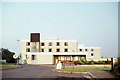
Traherne Hall
According to http://www.cardiffnetwork.cf.ac.uk/traherne this hall of residence was in Llwyn-y-Grant Road in Penylan until it was demolished in the mid-1990s and the site was developed for private housing.
Image: © Elliott Simpson
Taken: 17 Sep 1969
0.17 miles
4

Waterloo Road, Penylan, Cardiff
Looking northwestwards away from the corner of Colchester Avenue.
Image: © Jaggery
Taken: 14 Apr 2010
0.19 miles
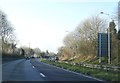
5
Junction of Colchester Ave and Waterloo Rd, Cardiff
Image: © John Lord
Taken: 23 Feb 2012
0.19 miles
6

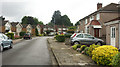
Baron's Court Road, Penylan, Cardiff
Houses on the east side of the road, viewed from the corner of Colchester Avenue.
Image: © Jaggery
Taken: 14 Apr 2010
0.19 miles
8
Oak Wood Avenue, Penylan
See also Image]; this view is from closer to the junction with Llanedeyrn Road.
Image: © Derek Harper
Taken: 16 Jun 2018
0.21 miles
9
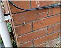
Ordnance Survey Cut Mark
This OS cut mark can be found on No67 Waterloo Road. It marks a point 43.245m above mean sea level.
Image: © Adrian Dust
Taken: 19 Nov 2017
0.21 miles
10
Oak Wood Avenue, Penylan
See Image]; the same bend can be seen.
Image: © Derek Harper
Taken: 16 Jun 2018
0.21 miles