IMAGES TAKEN NEAR TO
Birchwood Road, CARDIFF, CF23 5YB
Introduction
This page details the photographs taken nearby to Birchwood Road, CF23 5YB by members of the Geograph project.
The Geograph project started in 2005 with the aim of publishing, organising and preserving representative images for every square kilometre of Great Britain, Ireland and the Isle of Man.

There are currently over 7.5m images from over14,400 individuals and you can help contribute to the project by visiting https://www.geograph.org.uk
Image Map
Images are licensed for reuse under creativecommons.org/licenses/by-sa/2.0
Notes
- Clicking on the map will re-center to the selected point.
- The higher the marker number, the further away the image location is from the centre of the postcode.
Image Listing (13 Images Found)
Images are licensed for reuse under creativecommons.org/licenses/by-sa/2.0
Image
Details
Distance
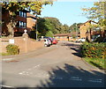
1
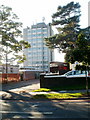
University Hall, Penylan, Cardiff
Viewed from Ty Gwyn Road. The multi-storey university hall is located on Birchwood Lane. It has accommodation for 673 students, either in standard rooms with shared bathroom facilities, or 251 more expensive rooms with en-suite facilities.
Image: © Jaggery
Taken: 11 Oct 2010
0.04 miles
2
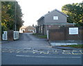
Entrance to Ty Gwyn School Annexe, Cardiff
Viewed across Ty Gwyn Road. The Annexe is part of Ty Gwyn School. The main building is in Vincent Road, Ely, Cardiff. Ty Gwyn is a local authority day special school for children and young people (aged 3–19) who have profound and multiple learning difficulties.
Image: © Jaggery
Taken: 11 Oct 2010
0.06 miles
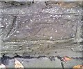
3
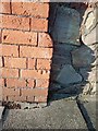
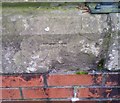
Cut Benchmark - Birchwood Road
A cut benchmark on the gatepost of the college entrance on Birchwood Road
Image: © Father Ted
Taken: 2 Jul 2020
0.08 miles
4
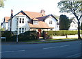
Corner of Ty Gwyn Road and Cyncoed Road, Cardiff
Detached house on the southern corner of Cyncoed Road and Ty Gwyn Road (on the right).
Image: © Jaggery
Taken: 11 Oct 2010
0.10 miles
5
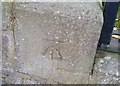
Ordnance Survey Cut Mark
This OS cut mark can be found on the wall of Cornborough House, Cyncoed Road. It marks a point 63.136m above mean sea level.
Image: © Adrian Dust
Taken: 19 Nov 2017
0.13 miles
6
Ordnance Survey Cut Mark
This OS cut mark can be found on the wall NE side of Cyncoed Road. It marks a point 64.935m above mean sea level.
Image: © Adrian Dust
Taken: 19 Nov 2017
0.16 miles
7
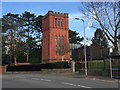
Water Tower
Grade II listed former water tower, first built in 1898 - now converted for residential use.
Image: © Alan Hughes
Taken: 1 Nov 2017
0.17 miles
8
Ordnance Survey Cut Mark
This OS cut mark can be found on the gatepost of No93 Cyncoed Road. It marks a point 61.472m above mean sea level.
Image: © Adrian Dust
Taken: 19 Nov 2017
0.17 miles
9
Glenside Court, Cardiff
Built in 1989, Glenside Court contains 52 flats. It is located on the eastern side of Ty Gwyn Road, just north of the bridge over Eastern Avenue (A48). There is a resident management staff and community alarm service. New residents must be at least 60 years old. Glenside Court consists of five buildings named Dyfed House, Powys House, Gwent House, Clwyd House and Gwynedd House.
Image: © Jaggery
Taken: 11 Oct 2010
0.19 miles
10
Ordnance Survey Cut Mark
This OS cut mark can be found on the wall of No39 Cyncoed Road. It marks a point 59.293m above mean sea level.
Image: © Adrian Dust
Taken: 19 Nov 2017
0.21 miles