IMAGES TAKEN NEAR TO
Marlborough Road, CARDIFF, CF23 5BU
Introduction
This page details the photographs taken nearby to Marlborough Road, CF23 5BU by members of the Geograph project.
The Geograph project started in 2005 with the aim of publishing, organising and preserving representative images for every square kilometre of Great Britain, Ireland and the Isle of Man.

There are currently over 7.5m images from over14,400 individuals and you can help contribute to the project by visiting https://www.geograph.org.uk
Image Map
Images are licensed for reuse under creativecommons.org/licenses/by-sa/2.0
Notes
- Clicking on the map will re-center to the selected point.
- The higher the marker number, the further away the image location is from the centre of the postcode.
Image Listing (65 Images Found)
Images are licensed for reuse under creativecommons.org/licenses/by-sa/2.0
Image
Details
Distance
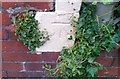
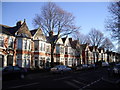
3
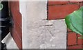
Ordnance Survey Cut Mark
This OS cut mark can be found on the NW face of No46 Sandringham Road. It marks a point 9.745m above mean sea level.
Image: © Adrian Dust
Taken: 12 Oct 2017
0.05 miles
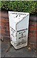
4
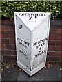
Old Milepost by the A469, Roath, Albany Road
By the A469, in parish of Roath (City of Cardiff District), Albany Road, almost opposite Roath Court Place.
Inscription reads:-
: NEWPORT / ROAD / ¼ / MILE : : CAERPHILLY / 7½ : : MERTHYR / ROAD / 2 / MILES :
Grade II listed by Cadw. Reference Number: 87772
https://cadwpublic-api.azurewebsites.net/reports/listedbuilding/FullReport?lang=&id=87772
Surveyed
Milestone Society National ID: GLA_NRMR02.
Image: © Milestone Society
Taken: Unknown
0.06 miles
5
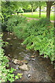
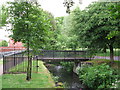
Roath Brook
Looking upstream from the footbridge shown in Image, with Roath Mill Gardens, a pleasant little listed park http://orapweb.rcahms.gov.uk/coflein//C/CPG217.pdf , extending across to Westville Road in the background. "The Roath Brook {runs} in a stone-revetted channel through the middle. This channel is in fact the former mill leat: the original brook was filled in and the water diverted into the leat."
Image: © Derek Harper
Taken: 16 Jun 2018
0.06 miles
6
Ordnance Survey Cut Mark
This OS cut mark can be found on the NE face of No16 Agincourt Road. It marks a point 10.019m above mean sea level.
Image: © Adrian Dust
Taken: 12 Oct 2017
0.07 miles
10
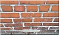
Ordnance Survey Cut Mark
This OS cut mark can be found on the wall of No259 Albany Road. It marks a point 8.574m above mean sea level.
Image: © Adrian Dust
Taken: 12 Oct 2017
0.08 miles