IMAGES TAKEN NEAR TO
Viaduct Road, CARDIFF, CF15 9XG
Introduction
This page details the photographs taken nearby to Viaduct Road, CF15 9XG by members of the Geograph project.
The Geograph project started in 2005 with the aim of publishing, organising and preserving representative images for every square kilometre of Great Britain, Ireland and the Isle of Man.

There are currently over 7.5m images from over14,400 individuals and you can help contribute to the project by visiting https://www.geograph.org.uk
Image Map
Images are licensed for reuse under creativecommons.org/licenses/by-sa/2.0
Notes
- Clicking on the map will re-center to the selected point.
- The higher the marker number, the further away the image location is from the centre of the postcode.
Image Listing (146 Images Found)
Images are licensed for reuse under creativecommons.org/licenses/by-sa/2.0
Image
Details
Distance
1
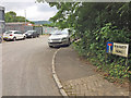
Viaduct Road Industrial Estate
Small industrial estate with a variety of businesses.
Image: © Stuart Lang
Taken: 22 Jun 2017
0.02 miles
2
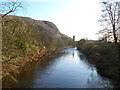
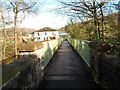
River Taff downstream from a footbridge, Taffs Well
The Taff flows away from this http://www.geograph.org.uk/photo/2726119 footbridge.
In the distance is a remnant of a railway viaduct. http://www.geograph.org.uk/photo/514531
Image: © Jaggery
Taken: 9 Dec 2011
0.04 miles
3
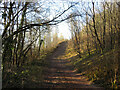
Track through Garth Wood
Track, a possible former quarry road, on the side of Lesser/Little Garth Hill.
Image: © Gareth James
Taken: 6 Apr 2021
0.04 miles
4
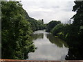
River Taff downstream
View from footbridge leading to Gwaelod-y-Garth. The remaining pillar of the old Barry Railway viaduct can just be made out in the distance.
Image: © Duncan and Gareth Alderson
Taken: 2 Aug 2007
0.05 miles
5
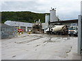
Readymixed concrete plant at Taffs Well
The readymix plant now operates as Tarmac, but in recent years has traded as Lafarge Tarmac and as Minimix Wales, which was its original name before being bought by Lafarge UK. Updates to the site signage and vehicle livery are in hand at the time of writing.
Image: © Richard Law
Taken: 7 Aug 2015
0.07 miles
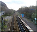
6
A view SE from Taffs Well railway station
Looking towards the bridge carrying Cardiff Road (A4054). The next station in this direction is Radyr, a suburb of Cardiff.
Image: © Jaggery
Taken: 9 Dec 2011
0.09 miles
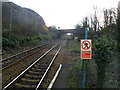
7
A view SE from Taffs Well railway station footbridge
Looking towards the bridge carrying the A4054 (Cardiff Road). The next station in this direction is Radyr, a suburb of Cardiff.
Image: © Jaggery
Taken: 9 Dec 2011
0.09 miles
8
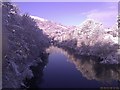
Snowy picture looking up River Taff from bridge
Picture taken from bridge over Taff between Gwaelod and Taff's Well.
Image: © Tori Sweet
Taken: 18 Dec 2010
0.09 miles
9
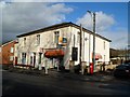
John Mills newsagents, Taffs Well
Located at 1 Cardiff Road (A4054). An unnamed road past the right side of the postbox leads to Taffs Well railway station.
Image: © Jaggery
Taken: 9 Dec 2011
0.10 miles
10
Footbridge across the Taff, Taffs Well
Viewed from the west bank of the River Taff looking towards Cardiff Road. The building on the left is John Mills newsagents. http://www.geograph.org.uk/photo/2725927
Image: © Jaggery
Taken: 9 Dec 2011
0.10 miles