IMAGES TAKEN NEAR TO
Penmaes, CARDIFF, CF15 9QS
Introduction
This page details the photographs taken nearby to Penmaes, CF15 9QS by members of the Geograph project.
The Geograph project started in 2005 with the aim of publishing, organising and preserving representative images for every square kilometre of Great Britain, Ireland and the Isle of Man.

There are currently over 7.5m images from over14,400 individuals and you can help contribute to the project by visiting https://www.geograph.org.uk
Image Map
Images are licensed for reuse under creativecommons.org/licenses/by-sa/2.0
Notes
- Clicking on the map will re-center to the selected point.
- The higher the marker number, the further away the image location is from the centre of the postcode.
Image Listing (126 Images Found)
Images are licensed for reuse under creativecommons.org/licenses/by-sa/2.0
Image
Details
Distance
1
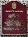
George's Corner plaque, Pentyrch
On the wall here. https://www.geograph.org.uk/photo/5887336
Image: © Jaggery
Taken: 22 Sep 2017
0.07 miles
2
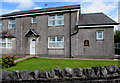
George's Corner flats, Bronllwyn, Pentyrch
The plaque https://www.geograph.org.uk/photo/5887337 on the wall shows that George's Corner was opened on March 20th 1990.
Image: © Jaggery
Taken: 22 Sep 2017
0.08 miles
3
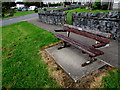
Pentyrch Community Council centenary bench
Located near George's Corner flats. https://www.geograph.org.uk/photo/5887336
The small plaque on the bench shows PENTYRCH COMMUNITY COUNCIL 1894-1994.
Image: © Jaggery
Taken: 22 Sep 2017
0.08 miles
4
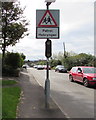
Warning sign - Patrol/Hebryngwr, Bronllwyn, Pentyrch
The English/Welsh sign faces southbound traffic on Bronllwyn on the approach to
Pentyrch Primary School.
Image: © Jaggery
Taken: 22 Sep 2017
0.08 miles
5
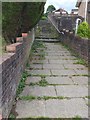
Footpath and Steps within Housing Estate
Stepped Path leading from Bronhaul towards Heol y Pentre, Pentyrch.
Image: © Alan Hughes
Taken: 12 Jul 2017
0.09 miles
6
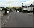
North along Bronllwyn, Pentyrch
Straight road towards the centre of the village.
Image: © Jaggery
Taken: 22 Sep 2017
0.09 miles
7
Village Hall direction sign, Bronllwyn, Pentyrch
The brown sign on a Bronllwyn lamppost points the way to the village hall. https://www.geograph.org.uk/photo/5546103
Image: © Jaggery
Taken: 22 Sep 2017
0.09 miles
8
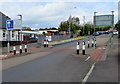
Traffic calming on Bronllwyn, Pentyrch
Vehicles on the camera side have priority over oncoming vehicles through a narrow part of Bronllwyn.
Image: © Jaggery
Taken: 22 Sep 2017
0.09 miles
9
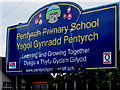
Pentyrch Primary School name sign, Pentyrch
Located on the right here https://www.geograph.org.uk/photo/5887972 the sign shows that Pentyrch Primary School is Ysgol Gynradd Pentyrch in Welsh.
Image: © Jaggery
Taken: 22 Sep 2017
0.09 miles
10
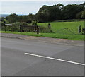
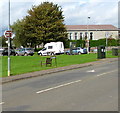
Roadside bench, Bronllwyn, Pentyrch
Facing a field near a field gate.
Image: © Jaggery
Taken: 22 Sep 2017
0.10 miles