IMAGES TAKEN NEAR TO
Penuel Road, CARDIFF, CF15 9QJ
Introduction
This page details the photographs taken nearby to Penuel Road, CF15 9QJ by members of the Geograph project.
The Geograph project started in 2005 with the aim of publishing, organising and preserving representative images for every square kilometre of Great Britain, Ireland and the Isle of Man.

There are currently over 7.5m images from over14,400 individuals and you can help contribute to the project by visiting https://www.geograph.org.uk
Image Map
Images are licensed for reuse under creativecommons.org/licenses/by-sa/2.0
Notes
- Clicking on the map will re-center to the selected point.
- The higher the marker number, the further away the image location is from the centre of the postcode.
Image Listing (52 Images Found)
Images are licensed for reuse under creativecommons.org/licenses/by-sa/2.0
Image
Details
Distance
1
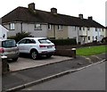
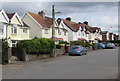
Row of houses, Penuel Road, Pentyrch
Extending for 45 metres along the south side of Penuel Road.
Image: © Jaggery
Taken: 22 Sep 2017
0.02 miles
2
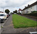
Long grass strip, Penuel Road, Pentyrch
A narrow tongue of grass extends for 45 metres on the south side of Penuel Road.
Image: © Jaggery
Taken: 22 Sep 2017
0.02 miles
3
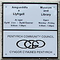
Pentyrch Museum and Library information board, Penuel Road, Pentyrch
Above the entrance here. http://www.geograph.org.uk/photo/5624788
Image: © Jaggery
Taken: 22 Sep 2017
0.02 miles
4
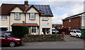
Pentyrch Museum and Library, Penuel Road, Pentyrch
http://www.geograph.org.uk/photo/5624790 to the information board above the entrance.
Image: © Jaggery
Taken: 22 Sep 2017
0.02 miles
5
Penuel Road semis, Pentyrch
Semi-detached houses on the north side of Penuel Road.
Image: © Jaggery
Taken: 22 Sep 2017
0.02 miles
6
West side of Bronhaul, Pentyrch
Houses on the west side of Bronhaul viewed across Penuel Road.
Image: © Jaggery
Taken: 22 Sep 2017
0.07 miles
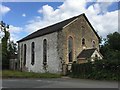
8
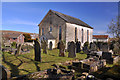
Grade II listed former Penuel Chapel, Pentyrch
The former Baptist chapel dating from 1837 was converted to a house in the late 20th century.
Grade II listed in 2000. http://www.geograph.org.uk/photo/5546497 to a broader view.
Image: © Jaggery
Taken: 22 Sep 2017
0.07 miles
9
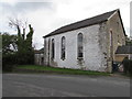
Penuel Chapel, Pentyrch
This Welsh Baptist chapel in Pentyrch was built in 1838.
Image: © Alan Hughes
Taken: 12 Jul 2017
0.07 miles
10
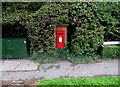
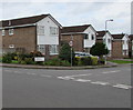
King George VI postbox, Bronllwyn, Pentyrch
Located here http://www.geograph.org.uk/photo/5624759 near the corner of Penuel Road.
King George VI reigned from December 11th 1936 to February 6th 1952.
A Virgin Media telecoms cabinet is on the left
Image: © Jaggery
Taken: 22 Sep 2017
0.08 miles