IMAGES TAKEN NEAR TO
Heol Gam, CARDIFF, CF15 9QA
Introduction
This page details the photographs taken nearby to Heol Gam, CF15 9QA by members of the Geograph project.
The Geograph project started in 2005 with the aim of publishing, organising and preserving representative images for every square kilometre of Great Britain, Ireland and the Isle of Man.

There are currently over 7.5m images from over14,400 individuals and you can help contribute to the project by visiting https://www.geograph.org.uk
Image Map (Loading...)


Getting Data...Please wait
Leaflet Map data © OpenStreetMap
Images are licensed for reuse under creativecommons.org/licenses/by-sa/2.0
Notes
- Clicking on the map will re-center to the selected point.
- The higher the marker number, the further away the image location is from the centre of the postcode.
Image Listing (87 Images Found)
Images are licensed for reuse under creativecommons.org/licenses/by-sa/2.0
Image
Details
Distance
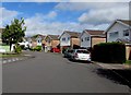
1
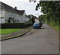
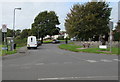
West along Heol Penllwyn, Pentyrch
Heol Penllwyn leads to Heol Gam.
Image: © Jaggery
Taken: 22 Sep 2017
0.03 miles
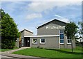
2
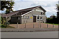
Pentyrch Village Hall
Viewed across Heol y Bryn. Pentyrch Village Hall's website records that this building dates from 1976, an ambitious project achieved by the efforts of local residents. The hall which still belongs to the community is a registered charity, maintained by income from lettings and fundraising. It is the centre for a variety of activities for community groups of all ages, and a popular venue for many events and social gatherings for residents of Pentyrch and the surrounding area.
Image: © Jaggery
Taken: 22 Sep 2017
0.08 miles
3
Pentyrch Village Hall
Viewed across Heol y Bryn in Pentyrch. Pentyrch Village Hall's website records that this building dates from 1976, an ambitious project achieved by the efforts of local residents. The hall which still belongs to the community is a registered charity, maintained by income from lettings and fundraising. It is the centre for a variety of activities for community groups of all ages, and a popular venue for many events and social gatherings for residents of Pentyrch and the surrounding area.
Image: © Jaggery
Taken: 22 Sep 2017
0.08 miles
4
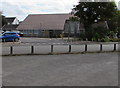
Northwest side of Pentyrch Village Hall
Viewed across Heol y Bryn. See http://www.geograph.org.uk/photo/5546089 for another view and some details.
Image: © Jaggery
Taken: 22 Sep 2017
0.09 miles
5
Maes y Sarn houses, Pentyrch
Houses on the east side of Maes y Sarn viewed from Heol y Bryn.
The Heol Penllwyn junction is on the left.
Image: © Jaggery
Taken: 22 Sep 2017
0.09 miles
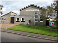
6
Neuadd y Pentref, Pentyrch
Adeiladwyd y Neuadd yn 1976 ar safle hen gapel Bronllwyn. Mae'r Neuadd yn glod i waith dygn y pentrefwyr a gasglodd arian i'w adeiladu a'i gynnal. Mae'n fwrlwm o weithgaredd.
The Hall was built in 1976 on the site of the old Bronllwyn chapel. The hall stands as a tribute to the villagers who raised the funds to build and maintain it. It is a hive activity.
Image: © Penri Williams
Taken: 7 Sep 2005
0.10 miles
7
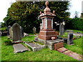
Williams family monument in a Pentyrch cemetery
In the burial ground of the demolished former Bronllwyn Independent Chapel.
Image: © Jaggery
Taken: 22 Sep 2017
0.10 miles
8
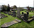
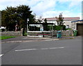
Small cemetery in Pentyrch
The burial ground of the demolished Bronllwyn Independent Chapel is set back from the north side of Heol-y-bryn.
Image: © Jaggery
Taken: 22 Sep 2017
0.10 miles
9
Junction of Heol y Bryn and Bronllwyn, Pentyrch
The 20mph speed limit on Bronllwyn on the camera side increases to 30mph along Heol y Bryn.
Image: © Jaggery
Taken: 22 Sep 2017
0.10 miles
10
Bus stop and shelter near a small cemetery, Pentyrch
On the corner of Temperance Court and Heol-y-bryn.
Image: © Jaggery
Taken: 22 Sep 2017
0.10 miles