IMAGES TAKEN NEAR TO
Garth Hill, CARDIFF, CF15 9NS
Introduction
This page details the photographs taken nearby to Garth Hill, CF15 9NS by members of the Geograph project.
The Geograph project started in 2005 with the aim of publishing, organising and preserving representative images for every square kilometre of Great Britain, Ireland and the Isle of Man.

There are currently over 7.5m images from over14,400 individuals and you can help contribute to the project by visiting https://www.geograph.org.uk
Image Map
Images are licensed for reuse under creativecommons.org/licenses/by-sa/2.0
Notes
- Clicking on the map will re-center to the selected point.
- The higher the marker number, the further away the image location is from the centre of the postcode.
Image Listing (5 Images Found)
Images are licensed for reuse under creativecommons.org/licenses/by-sa/2.0
Image
Details
Distance
1
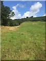
View towards Penmynydd Cottage
View uphill across a field towards Penmynydd Cottage.
Image: © Alan Hughes
Taken: 13 Aug 2019
0.09 miles
2
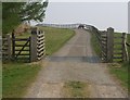
Ty'n-y-Ffald Entrance
This "entrance" is half way down a track leading to the house
Image: © Steve Sheppard
Taken: 15 Apr 2007
0.12 miles
3
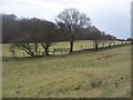
Field boundary between Caerwen and Pentyrch
A stile can be seen in the small group of trees.
Image: © John Light
Taken: 28 Jan 2010
0.16 miles
4
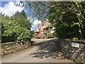
Pinecroft Cattery
Entrance to Pinecroft cattery.
Image: © Alan Hughes
Taken: 13 Aug 2019
0.18 miles
5
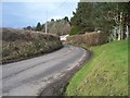
Road to Soar
The left hand fork of the minor road leading north from Pentyrch.It continues on towards Efail Isaf.
Image: © John Light
Taken: 28 Jan 2010
0.18 miles