IMAGES TAKEN NEAR TO
Parc-y-Coed, CARDIFF, CF15 9LW
Introduction
This page details the photographs taken nearby to Parc-y-Coed, CF15 9LW by members of the Geograph project.
The Geograph project started in 2005 with the aim of publishing, organising and preserving representative images for every square kilometre of Great Britain, Ireland and the Isle of Man.

There are currently over 7.5m images from over14,400 individuals and you can help contribute to the project by visiting https://www.geograph.org.uk
Image Map
Images are licensed for reuse under creativecommons.org/licenses/by-sa/2.0
Notes
- Clicking on the map will re-center to the selected point.
- The higher the marker number, the further away the image location is from the centre of the postcode.
Image Listing (38 Images Found)
Images are licensed for reuse under creativecommons.org/licenses/by-sa/2.0
Image
Details
Distance
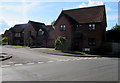
1
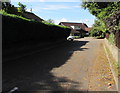
Green Acre, Creigiau
Cul-de-sac on the west side of Cardiff Road.
Image: © Jaggery
Taken: 19 Sep 2017
0.05 miles
2
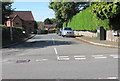
Parc-y-Coed, Creigiau
Viewed across Cardiff Road. Maes Cadwgan houses http://www.geograph.org.uk/photo/5543514 are ahead on the left.
Image: © Jaggery
Taken: 19 Sep 2017
0.07 miles
3
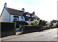
Cardiff Road semis, Creigiau
Semi-detached houses on the east side of Cardiff Road viewed from the corner of Green Acre.
Image: © Jaggery
Taken: 19 Sep 2017
0.08 miles
4
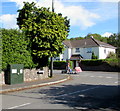
BT telecoms cabinet near a Creigiau corner
On the Parc-y-Coed side of the Cardiff Road corner.
Image: © Jaggery
Taken: 19 Sep 2017
0.09 miles
5
Maes Cadwgan, Creigiau
Cul-de-sac on the south side of Parc-y-Coed.
Image: © Jaggery
Taken: 19 Sep 2017
0.09 miles
6
When red light shows wait here, Cardiff Road, Creigiau
On September 19th 2017, temporary traffic lights maintain an alternating
flow of one-way traffic past a coned-off part of Cardiff Road.
Image: © Jaggery
Taken: 19 Sep 2017
0.09 miles
7
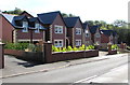
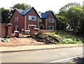
Recently-built houses, Cardiff Road, Creigiau
On a former greenfield site, viewed in September 2017.
Image: © Jaggery
Taken: 19 Sep 2017
0.12 miles
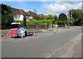
8
Creigiau Inn
The road on the left leads to the village of Pentyrch, that on the right to the A4119.
Image: © Duncan and Gareth Alderson
Taken: 28 Jul 2007
0.13 miles
9
Oaklands, Cardiff Road, Creigiau
New house nearing completion in September 2017.
Image: © Jaggery
Taken: 19 Sep 2017
0.13 miles
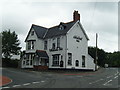
10
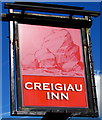
Creigiau Inn name sign, Creigiau
On the Cardiff Road side of this inn. http://www.geograph.org.uk/photo/5543335
Creigiau is Welsh for rocks.
Image: © Jaggery
Taken: 19 Sep 2017
0.14 miles