IMAGES TAKEN NEAR TO
Ravensbrook, CARDIFF, CF15 8LT
Introduction
This page details the photographs taken nearby to Ravensbrook, CF15 8LT by members of the Geograph project.
The Geograph project started in 2005 with the aim of publishing, organising and preserving representative images for every square kilometre of Great Britain, Ireland and the Isle of Man.

There are currently over 7.5m images from over14,400 individuals and you can help contribute to the project by visiting https://www.geograph.org.uk
Image Map
Images are licensed for reuse under creativecommons.org/licenses/by-sa/2.0
Notes
- Clicking on the map will re-center to the selected point.
- The higher the marker number, the further away the image location is from the centre of the postcode.
Image Listing (62 Images Found)
Images are licensed for reuse under creativecommons.org/licenses/by-sa/2.0
Image
Details
Distance
1
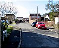
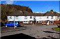
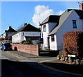
Ravensbrook, Morganstown, Cardiff
Houses at the western end of Heol Syr Lewis.
Image: © Jaggery
Taken: 3 Mar 2015
0.02 miles
2
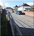
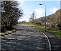
West along Heol Syr Lewis, Morganstown, Cardiff
From railings at the edge of the slightly elevated pavement near the corner of Ty-Nant Road.
Image: © Jaggery
Taken: 3 Mar 2015
0.06 miles
3
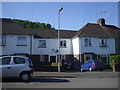
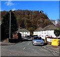
Houses in Heol Syr Lewis, Morganstown
The central house has a plaque with CRDC (Cardiff Rural District Council) 1947.
Image: © John Lord
Taken: 22 May 2010
0.06 miles
4
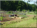
Allotments, Morganstown
Alongside Ffordd Treforgan
Image: © John Lord
Taken: 22 May 2010
0.07 miles
5
Houses built in 1947, Morganstown, Cardiff
An inscription on the Heol Syr Lewis houses shows CRDC 1947. CRDC = Cardiff Rural District Council.
Image: © Jaggery
Taken: 3 Mar 2015
0.07 miles
6
Ffordd Treforgan, Morganstown, Cardiff
Road to Morganstown from the B4262 Ty-Nant Road. Treforgan is the Welsh name for Morganstown.
Image: © Jaggery
Taken: 3 Mar 2015
0.09 miles
7
Garth Close, Morganstown, Cardiff
70 metre long cul-de-sac on the north side of Heol Syr Lewis.
Image: © Jaggery
Taken: 3 Mar 2015
0.10 miles
8
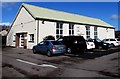
Morganstown Village Hall, Cardiff
Accessed from Heol Syr Lewis, on the west side of Ty-Nant Road. The main hall and a small additional room are available for hire. Although Morganstown is now an outer suburb of Cardiff, it has retained some village features.
Image: © Jaggery
Taken: 3 Mar 2015
0.10 miles
9
Suburban corner in Morganstown, Cardiff
Corner of Heol Syr Lewis and Gelynis Terrace North.
Image: © Jaggery
Taken: 3 Mar 2015
0.11 miles
10
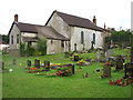
Bethel Chapel, Morganstown.
The Bethel Chapel was built in 1842 to replace a shoemaker's shop which was used as a meeting house.
Image: © Robin Williams
Taken: 29 Jul 2005
0.12 miles