IMAGES TAKEN NEAR TO
Glan-y-Ffordd, CARDIFF, CF15 7SQ
Introduction
This page details the photographs taken nearby to Glan-y-Ffordd, CF15 7SQ by members of the Geograph project.
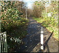
The Geograph project started in 2005 with the aim of publishing, organising and preserving representative images for every square kilometre of Great Britain, Ireland and the Isle of Man.

There are currently over 7.5m images from over14,400 individuals and you can help contribute to the project by visiting https://www.geograph.org.uk
Image Map (Loading...)


Getting Data...Please wait
Leaflet Map data © OpenStreetMap
Images are licensed for reuse under creativecommons.org/licenses/by-sa/2.0
Notes
- Clicking on the map will re-center to the selected point.
- The higher the marker number, the further away the image location is from the centre of the postcode.
Image Listing (26 Images Found)
Images are licensed for reuse under creativecommons.org/licenses/by-sa/2.0
Image
Details
Distance
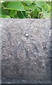
1
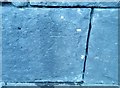
Ordnance Survey Cut Mark
This OS cut mark can be found on the east buttress of the railway bridge. It marks a point 37.328m above mean sea level.
Image: © Adrian Dust
Taken: 20 Jul 2020
0.08 miles
2
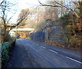
Remnants of the Cardiff Railway near Nantgarw
This view north along the A4054 towards a footbridge shows stonework on the right, remnants of an embankment on the Cardiff Railway, which was absorbed by the Great Western Railway on January 1 1922 under the terms of the Railways Act 1921. The letters CR (Cardiff Railway) are visible near the top of the column in the middle of the stonework.
The original railway bridge is long gone. The modern footbridge carries a footpath and cycle way which use the trackbed of the dismantled railway.
Image: © Jaggery
Taken: 9 Dec 2011
0.08 miles
3
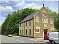
Capel Glandwr Taf, Taffs Well
Welsh non-conformist chapel built in 1859 and converted for residential use in 1997.
Image: © Alan Hughes
Taken: 5 Jun 2019
0.11 miles
4
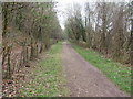
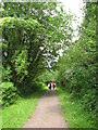
Taff Trail between Nantgarw and Castell Coch
The trail uses the old Barry Railway line at this point. NCN8 (Lon Las Cymru) runs parallel out of shot to the right.
Image: © John Light
Taken: 31 Mar 2011
0.13 miles
5
Footpath and cycle route using former railway tracked near Nantgarw
This was formerly the trackbed of the Cardiff Railway, which was absorbed by the Great Western Railway on January 1st 1922. Stonework remnants of the Cardiff Railway are nearby. http://www.geograph.org.uk/photo/2730760
Image: © Jaggery
Taken: 9 Dec 2011
0.14 miles
6
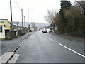
Glan-y-Llyn village entrance, Cardiff Road
Image: © Colin Pyle
Taken: 4 Jan 2011
0.14 miles
7
Ordnance Survey Rivet
This OS rivet can be found on the east parapet of the bridge. It marks a point 42.679m above mean sea level.
Image: © Adrian Dust
Taken: 20 Jul 2020
0.14 miles
8
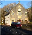
Former Glandwr Taf Welsh Independent chapel near Glan-y-llyn
Converted into a dwelling in 1997, with the front of the former chapel preserved.
A faded stone inscription in Welsh shows that the chapel opened in 1859.
Located on the east side of Cardiff Road between Glan-y-llyn and Nantgarw.
Image: © Jaggery
Taken: 9 Dec 2011
0.16 miles
9
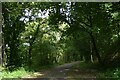
Taff Trail
Taff Trail between Castell Coch and Nantgarw, on the section that was a former railway line.
Image: © Gareth James
Taken: 2 Aug 2009
0.16 miles
10
Taff Trail west of Craig yr Allt
The ridge of Craig yr Allt means that the Taff Trail and two roads are squeezed into about 200m of woods between hill and river; the woods keep the noise of the roads away from cyclists
Image: © David Smith
Taken: 22 Sep 2022
0.18 miles