IMAGES TAKEN NEAR TO
Cardiff Road, CARDIFF, CF15 7RE
Introduction
This page details the photographs taken nearby to Cardiff Road, CF15 7RE by members of the Geograph project.
The Geograph project started in 2005 with the aim of publishing, organising and preserving representative images for every square kilometre of Great Britain, Ireland and the Isle of Man.

There are currently over 7.5m images from over14,400 individuals and you can help contribute to the project by visiting https://www.geograph.org.uk
Image Map
Images are licensed for reuse under creativecommons.org/licenses/by-sa/2.0
Notes
- Clicking on the map will re-center to the selected point.
- The higher the marker number, the further away the image location is from the centre of the postcode.
Image Listing (150 Images Found)
Images are licensed for reuse under creativecommons.org/licenses/by-sa/2.0
Image
Details
Distance
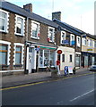
1
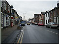
Cardiff Road with Taffs Well Post Office on the left
Image: © Colin Pyle
Taken: 4 Jan 2011
0.03 miles
2
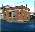
Former National Provincial Bank building, Cardiff Road, Taffs Well
The former bank branch on the corner of Cardiff Road and Leon Avenue is the premises of Alwyn Jones, architects.
Image: © Jaggery
Taken: 9 Dec 2011
0.03 miles
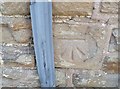
3
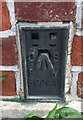
Ordnance Survey Flush Bracket (S9241)
This OS Flush Bracket can be found on the old Bank building, Cardiff Road. It marks a point 34.549m above mean sea level.
Image: © Adrian Dust
Taken: 17 Aug 2019
0.05 miles
4
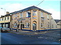
The Anchor Hotel, Taffs Well
Hotel and restaurant located on the corner of Cardiff Road and Anchor Street.
A large inscription at street level states
"From the earliest days of the Industrial Revolution, Anchors and their Chains have been produced in this part of Wales.
Prior to 1851 these were of Admiralty or Patent Pattern. A large Anchor of this type dredged up from the Bristol Channel features in the interior of our Restaurant"
The Anchor formerly described itself as a Mongolian Restaurant. Although "Mongolian" no longer appears above Restaurant on the exterior, a depiction of a Mongolian horseman remains.
Image: © Jaggery
Taken: 9 Dec 2011
0.05 miles
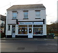
5
Taffs Well Post Office
Located at 27 Cardiff Road, Taffs Well.
Image: © Jaggery
Taken: 9 Dec 2011
0.06 miles
6
Hoss Equine, Taffs Well
Stocking a wide range of products for horses and their owners and riders, the store opened in August 2011 at 28 Cardiff Road, facing Church Street.
Earlier occupiers of the premises were Thomas & Rose who provided financial and property services.
Image: © Jaggery
Taken: 9 Dec 2011
0.06 miles
7
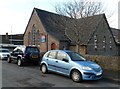
Church of St Mary and St James, Taffs Well
Church in Wales church located on Church Street, near the Cardiff Road junction.
Image: © Jaggery
Taken: 9 Dec 2011
0.06 miles
8
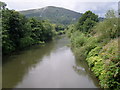
River Taff upstream
View from footbridge leading to Gwaelod-y-Garth. Garth Hill is in the distance.
Image: © Duncan and Gareth Alderson
Taken: 2 Aug 2007
0.06 miles
9
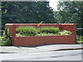
A new use
A novel idea for a disused urinal block. Now a floral display.
Image: © Duncan and Gareth Alderson
Taken: 2 Aug 2007
0.08 miles
10
Ordnance Survey Cut Mark
This OS cut mark can be found on No1 Alfreds Terrace. It marks a point 34.692m above mean sea level.
Image: © Adrian Dust
Taken: 17 Aug 2019
0.08 miles