IMAGES TAKEN NEAR TO
Green Meadow Drive, CARDIFF, CF15 7LU
Introduction
This page details the photographs taken nearby to Green Meadow Drive, CF15 7LU by members of the Geograph project.
The Geograph project started in 2005 with the aim of publishing, organising and preserving representative images for every square kilometre of Great Britain, Ireland and the Isle of Man.

There are currently over 7.5m images from over14,400 individuals and you can help contribute to the project by visiting https://www.geograph.org.uk
Image Map
Images are licensed for reuse under creativecommons.org/licenses/by-sa/2.0
Notes
- Clicking on the map will re-center to the selected point.
- The higher the marker number, the further away the image location is from the centre of the postcode.
Image Listing (29 Images Found)
Images are licensed for reuse under creativecommons.org/licenses/by-sa/2.0
Image
Details
Distance
1
Edge of Greenmeadow Wood, Tongwynlais
The view from the Pantgwynlais (a residential road) along Greenmeadow Drive towards Greenmeadow Wood.
Image: © Jaggery
Taken: 29 Nov 2010
0.04 miles
2
West side of Greenmeadow Drive, Tongwynlais
Viewed from the corner of Pantgwynlais (a residential road). In the background is Greenmeadow Wood.
Image: © Jaggery
Taken: 29 Nov 2010
0.08 miles
3
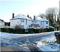
Castle View, Tongwynlais
Houses at the western end of Castle View, on the corner of Pantgwynlais (a residential road).
Image: © Jaggery
Taken: 29 Nov 2010
0.09 miles
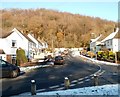
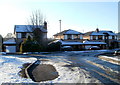
4
Pantgwynlais, Tongwynlais
Houses on the north side of the road, viewed from the corner of Cae Lewis. There are no houses on the southern side of this (western) part of Pantgwynlais. A row of trees shields the houses from traffic on Merthyr Road. There are houses on the south side at the eastern end of Pantgwynlais.
Image: © Jaggery
Taken: 29 Nov 2010
0.14 miles
5

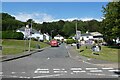
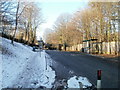
Start of cycle route, Merthyr Road, Tongwynlais
At the eastern edge of Tongwynlais, a footpath and cycle route heads away SSE from Merthyr Road.
The sign on the right has an arrow pointing along the route and shows Pantmawr and Whitchurch.
Image: © Jaggery
Taken: 29 Nov 2010
0.15 miles
6
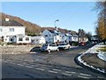
Bus stops, eastern edge of Tongwynlais
The bus stops are on Merthyr Road (A4054). Although Tongwynlais has been absorbed into the City of Cardiff, Cardiff Bus does not have a service to the village. Most buses through Tongwynlais are provided by Stagecoach.
Image: © Jaggery
Taken: 29 Nov 2010
0.15 miles
7
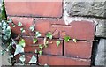
Ordnance Survey Cut Mark
This OS cut mark can be found on the school wall. It marks a point 38.505m above mean sea level.
Image: © Adrian Dust
Taken: 20 Jul 2020
0.16 miles
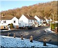
8
Cwm Gwynlais, Tongwynlais
Houses near the eastern edge of Tongwynlais, on a street named Cwm Gwynlais, at the corner of Pwllhelyg (on the left). Cwm Gwynlais connects with Merthyr Road, a few metres behind the camera.
Image: © Jaggery
Taken: 29 Nov 2010
0.17 miles
9
Ordnance Survey Flush Bracket (S9242)
This OS Flush Bracket can be found on the north face of the school. It marks a point 36.868m above mean sea level.
Image: © Adrian Dust
Taken: 20 Jul 2020
0.17 miles