IMAGES TAKEN NEAR TO
Caer Wenallt, CARDIFF, CF14 7HA
Introduction
This page details the photographs taken nearby to Caer Wenallt, CF14 7HA by members of the Geograph project.
The Geograph project started in 2005 with the aim of publishing, organising and preserving representative images for every square kilometre of Great Britain, Ireland and the Isle of Man.

There are currently over 7.5m images from over14,400 individuals and you can help contribute to the project by visiting https://www.geograph.org.uk
Image Map
Images are licensed for reuse under creativecommons.org/licenses/by-sa/2.0
Notes
- Clicking on the map will re-center to the selected point.
- The higher the marker number, the further away the image location is from the centre of the postcode.
Image Listing (8 Images Found)
Images are licensed for reuse under creativecommons.org/licenses/by-sa/2.0
Image
Details
Distance
2
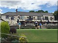
Whitchurch Golf Club
Golfers using the practice putting green in front of the clubhouse at Whitchurch Golf Club.
Image: © Alan Hughes
Taken: 12 Jul 2017
0.16 miles
3
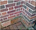
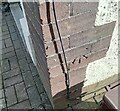
Ordnance Survey Cut Mark
This OS cut mark can be found on No137 Pantmawr Road. It marks a point 64.215m above mean sea level.
Image: © Adrian Dust
Taken: 26 Feb 2024
0.19 miles
4
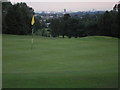
Whitchurch golf club, Cardiff
One of the holes at Whitchurch golf club, ( not sure which number but right behind the clubhouse, 18 ??? ) with the city in the background.
Image: © Steve Chapple
Taken: 6 Sep 2005
0.20 miles
5
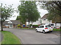
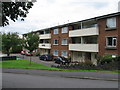
Dan y Graig
1970s detached houses in Pantmawr.
Image: © Burgess Von Thunen
Taken: 31 May 2012
0.20 miles
6
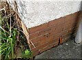
Ordnance Survey Cut Mark
This OS cut mark can be found on No70 Pantmawr Road. It marks a point 44.531m above mean sea level.
Image: © Adrian Dust
Taken: 26 Feb 2024
0.24 miles
7
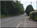
Pantmawr Road
Pantmawr Road running alongside Whitchurch Golf Club.
Image: © Alan Hughes
Taken: 12 Jul 2017
0.24 miles
8
Ordnance Survey Cut Mark
This OS cut mark can be found on No153 Pantmawr Road. It marks a point 64.807m above mean sea level.
Image: © Adrian Dust
Taken: 26 Feb 2024
0.24 miles