IMAGES TAKEN NEAR TO
Heol Nant Castan, CARDIFF, CF14 6RP
Introduction
This page details the photographs taken nearby to Heol Nant Castan, CF14 6RP by members of the Geograph project.
The Geograph project started in 2005 with the aim of publishing, organising and preserving representative images for every square kilometre of Great Britain, Ireland and the Isle of Man.

There are currently over 7.5m images from over14,400 individuals and you can help contribute to the project by visiting https://www.geograph.org.uk
Image Map
Images are licensed for reuse under creativecommons.org/licenses/by-sa/2.0
Notes
- Clicking on the map will re-center to the selected point.
- The higher the marker number, the further away the image location is from the centre of the postcode.
Image Listing (6 Images Found)
Images are licensed for reuse under creativecommons.org/licenses/by-sa/2.0
Image
Details
Distance
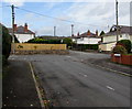
2
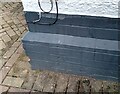
Ordnance Survey Cut Mark
This OS cut mark can be found on No52 Wenallt Road. It marks a point 62.758m above mean sea level.
Image: © Adrian Dust
Taken: 26 Feb 2024
0.19 miles
3
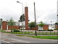
Church of Jesus Christ of Latter-Day Saints, Rhiwbina, Cardiff
Image: © Gareth James
Taken: 31 Jul 2010
0.19 miles
4
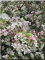
Spring blossom
Cefn Onn Park in spring.
Image: © Alan Hughes
Taken: 25 Apr 2024
0.21 miles
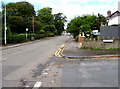
5
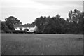
Junction of Lon-y-deri and Lon-y-rhyd, Rhiwbina, Cardiff
Viewed from Lon-y-deri. The cul-de-sac Groes Lon is ahead on the right.
Image: © Jaggery
Taken: 9 Oct 2019
0.24 miles
6
NW along Heol-y-deri, Rhiwbina, Cardiff
Viewed from the corner of Lon-y-rhyd in a leafy northern suburb of Cardiff.
Image: © Jaggery
Taken: 9 Oct 2019
0.24 miles