IMAGES TAKEN NEAR TO
Clos William, CARDIFF, CF14 6QJ
Introduction
This page details the photographs taken nearby to Clos William, CF14 6QJ by members of the Geograph project.
The Geograph project started in 2005 with the aim of publishing, organising and preserving representative images for every square kilometre of Great Britain, Ireland and the Isle of Man.

There are currently over 7.5m images from over14,400 individuals and you can help contribute to the project by visiting https://www.geograph.org.uk
Image Map
Images are licensed for reuse under creativecommons.org/licenses/by-sa/2.0
Notes
- Clicking on the map will re-center to the selected point.
- The higher the marker number, the further away the image location is from the centre of the postcode.
Image Listing (4 Images Found)
Images are licensed for reuse under creativecommons.org/licenses/by-sa/2.0
Image
Details
Distance
3
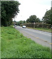
Thornhill Road enters 40mph zone, Cardiff
Although this location is within the northern suburbs of Cardiff, the speed limit is raised from 30mph to 40mph along a stretch of Thornhill Road where a long line of hedges prevents ingress by pedestrians from nearby Johnston Road and Edgehill Avenue.
Image: © Jaggery
Taken: 12 Aug 2010
0.22 miles
4
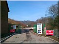
Reception office, Thornhill Cemetery, Cardiff
The building is located in the southeast of the cemetery, close to the entrance drive. http://www.geograph.org.uk/photo/2009067
Image: © Jaggery
Taken: 12 Aug 2010
0.25 miles